You are here: Home > Network List > GS - US Geological Survey Networks Stations List
> Station ASA5 ASA5 > Earthquake Result Viewer
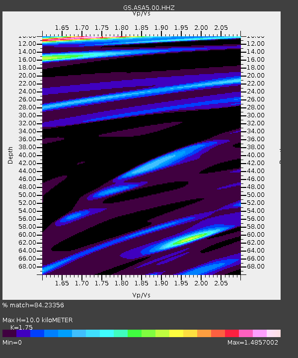
ASA5 ASA5 - Earthquake Result Viewer
| Earthquake location: |
Southeast Of Loyalty Islands |
| Earthquake latitude/longitude: |
-22.9/171.2 |
| Earthquake time(UTC): |
2021/02/11 (042) 08:22:10 GMT |
| Earthquake Depth: |
10 km |
| Earthquake Magnitude: |
5.9 mww |
| Earthquake Catalog/Contributor: |
NEIC PDE/us |
|
| Network: |
GS US Geological Survey Networks |
| Station: |
ASA5 ASA5 |
| Lat/Lon: |
34.94 N/106.46 W |
| Elevation: |
1835 m |
|
| Distance: |
96.8 deg |
| Az: |
55.075 deg |
| Baz: |
247.013 deg |
| Ray Param: |
0.040405907 |
| Estimated Moho Depth: |
10.0 km |
| Estimated Crust Vp/Vs: |
1.75 |
| Assumed Crust Vp: |
6.502 km/s |
| Estimated Crust Vs: |
3.715 km/s |
| Estimated Crust Poisson's Ratio: |
0.26 |
|
| Radial Match: |
84.23356 % |
| Radial Bump: |
265 |
| Transverse Match: |
76.69519 % |
| Transverse Bump: |
400 |
| SOD ConfigId: |
23341671 |
| Insert Time: |
2021-02-25 09:30:06.273 +0000 |
| GWidth: |
2.5 |
| Max Bumps: |
400 |
| Tol: |
0.001 |
|

Signal To Noise
| Channel | StoN | STA | LTA |
| GS:ASA5:00:HHZ:20210211T08:35:09.789998Z | 1.567269 | 5.111747E-7 | 3.261563E-7 |
| GS:ASA5:00:HH1:20210211T08:35:09.789998Z | 1.4091079 | 4.219205E-7 | 2.9942385E-7 |
| GS:ASA5:00:HH2:20210211T08:35:09.789998Z | 2.1939497 | 5.555478E-7 | 2.532181E-7 |
| Arrivals |
| Ps | 1.2 SECOND |
| PpPs | 4.1 SECOND |
| PsPs/PpSs | 5.3 SECOND |


