You are here: Home > Network List > XW97 - Tien Shan Continental Dynamics Stations List
> Station ARA XW.ARA > Earthquake Result Viewer
ARA XW.ARA - Earthquake Result Viewer

| Earthquake location: |
Minahassa Peninsula, Sulawesi |
| Earthquake latitude/longitude: |
0.3/122.1 |
| Earthquake time(UTC): |
2000/04/03 (094) 08:55:00 GMT |
| Earthquake Depth: |
187 km |
| Earthquake Magnitude: |
5.6 MB, 5.5 MW, 5.4 MW |
| Earthquake Catalog/Contributor: |
WHDF/NEIC |
|
| Network: |
XW Tien Shan Continental Dynamics |
| Station: |
ARA XW.ARA |
| Lat/Lon: |
41.85 N/74.33 E |
| Elevation: |
1484 m |
|
| Distance: |
59.6 deg |
| Az: |
320.152 deg |
| Baz: |
120.95 deg |
| Ray Param: |
0.061469372 |
| Estimated Moho Depth: |
17.25 km |
| Estimated Crust Vp/Vs: |
1.69 |
| Assumed Crust Vp: |
6.491 km/s |
| Estimated Crust Vs: |
3.852 km/s |
| Estimated Crust Poisson's Ratio: |
0.23 |
|
| Radial Match: |
81.965576 % |
| Radial Bump: |
400 |
| Transverse Match: |
70.14253 % |
| Transverse Bump: |
400 |
| SOD ConfigId: |
20082 |
| Insert Time: |
2010-02-26 15:18:09.618 +0000 |
| GWidth: |
2.5 |
| Max Bumps: |
400 |
| Tol: |
0.001 |
|
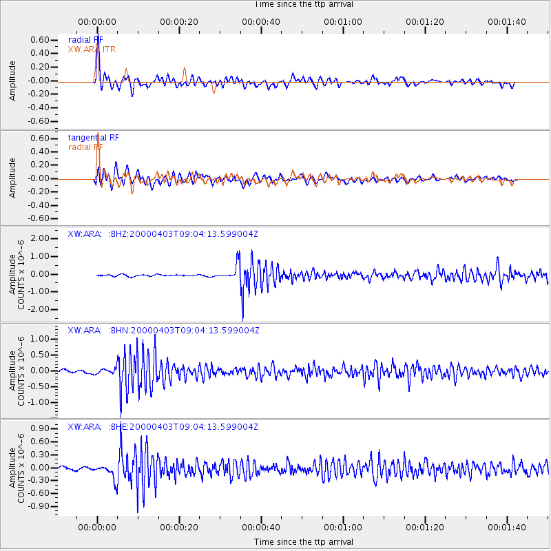
Signal To Noise
| Channel | StoN | STA | LTA |
| XW:ARA: :BHN:20000403T09:04:13.599004Z | 1.7203754 | 8.2572036E-8 | 4.7996522E-8 |
| XW:ARA: :BHE:20000403T09:04:13.599004Z | 4.7846394 | 1.7631552E-7 | 3.6850324E-8 |
| XW:ARA: :BHZ:20000403T09:04:13.599004Z | 10.579081 | 4.6877355E-7 | 4.431137E-8 |
| Arrivals |
| Ps | 1.9 SECOND |
| PpPs | 6.8 SECOND |
| PsPs/PpSs | 8.7 SECOND |


