You are here: Home > Network List > CI - Caltech Regional Seismic Network Stations List
> Station MPM Manuel Prospect Mine, California, USA > Earthquake Result Viewer
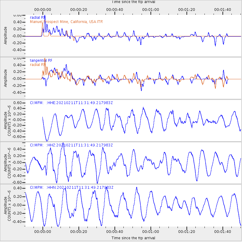
MPM Manuel Prospect Mine, California, USA - Earthquake Result Viewer
*The percent match for this event was below the threshold and hence no stack was calculated.
| Earthquake location: |
Southeast Of Loyalty Islands |
| Earthquake latitude/longitude: |
-23.1/172.0 |
| Earthquake time(UTC): |
2021/02/11 (042) 11:19:26 GMT |
| Earthquake Depth: |
10 km |
| Earthquake Magnitude: |
5.6 mb |
| Earthquake Catalog/Contributor: |
NEIC PDE/us |
|
| Network: |
CI Caltech Regional Seismic Network |
| Station: |
MPM Manuel Prospect Mine, California, USA |
| Lat/Lon: |
36.06 N/117.49 W |
| Elevation: |
185 m |
|
| Distance: |
88.8 deg |
| Az: |
49.815 deg |
| Baz: |
240.241 deg |
| Ray Param: |
$rayparam |
*The percent match for this event was below the threshold and hence was not used in the summary stack. |
|
| Radial Match: |
74.79311 % |
| Radial Bump: |
400 |
| Transverse Match: |
61.89533 % |
| Transverse Bump: |
400 |
| SOD ConfigId: |
23341671 |
| Insert Time: |
2021-02-25 12:25:19.813 +0000 |
| GWidth: |
2.5 |
| Max Bumps: |
400 |
| Tol: |
0.001 |
|
Signal To Noise
| Channel | StoN | STA | LTA |
| CI:MPM: :HHZ:20210211T11:31:49.217983Z | 1.6717689 | 2.5754287E-7 | 1.540541E-7 |
| CI:MPM: :HHN:20210211T11:31:49.217983Z | 1.2066168 | 3.2161404E-7 | 2.66542E-7 |
| CI:MPM: :HHE:20210211T11:31:49.217983Z | 1.012987 | 3.0007362E-7 | 2.9622652E-7 |
| Arrivals |
| Ps | |
| PpPs | |
| PsPs/PpSs | |


