You are here: Home > Network List > UW - Pacific Northwest Regional Seismic Network Stations List
> Station LON Longmire CREST broad-band > Earthquake Result Viewer
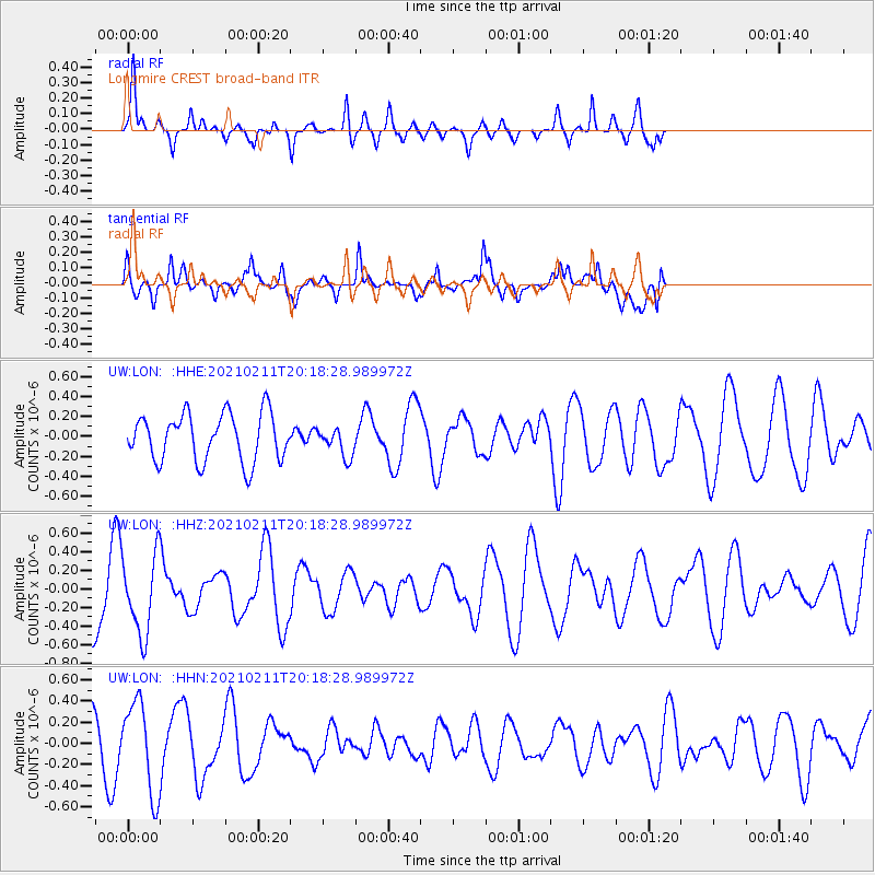
LON Longmire CREST broad-band - Earthquake Result Viewer
*The percent match for this event was below the threshold and hence no stack was calculated.
| Earthquake location: |
Southeast Of Loyalty Islands |
| Earthquake latitude/longitude: |
-22.6/171.2 |
| Earthquake time(UTC): |
2021/02/11 (042) 20:05:53 GMT |
| Earthquake Depth: |
10 km |
| Earthquake Magnitude: |
5.2 Mww |
| Earthquake Catalog/Contributor: |
NEIC PDE/us |
|
| Network: |
UW Pacific Northwest Regional Seismic Network |
| Station: |
LON Longmire CREST broad-band |
| Lat/Lon: |
46.75 N/121.81 W |
| Elevation: |
853 m |
|
| Distance: |
91.7 deg |
| Az: |
39.284 deg |
| Baz: |
238.306 deg |
| Ray Param: |
$rayparam |
*The percent match for this event was below the threshold and hence was not used in the summary stack. |
|
| Radial Match: |
58.569927 % |
| Radial Bump: |
302 |
| Transverse Match: |
62.208294 % |
| Transverse Bump: |
400 |
| SOD ConfigId: |
23341671 |
| Insert Time: |
2021-02-25 21:18:53.016 +0000 |
| GWidth: |
2.5 |
| Max Bumps: |
400 |
| Tol: |
0.001 |
|
Signal To Noise
| Channel | StoN | STA | LTA |
| UW:LON: :HHZ:20210211T20:18:28.989972Z | 1.1685274 | 4.2033267E-7 | 3.5971146E-7 |
| UW:LON: :HHN:20210211T20:18:28.989972Z | 2.715687 | 4.2550727E-7 | 1.5668495E-7 |
| UW:LON: :HHE:20210211T20:18:28.989972Z | 0.6058032 | 1.4399868E-7 | 2.3769879E-7 |
| Arrivals |
| Ps | |
| PpPs | |
| PsPs/PpSs | |


