You are here: Home > Network List > CI - Caltech Regional Seismic Network Stations List
> Station DGR Domenigoni Reservoir, California, USA > Earthquake Result Viewer
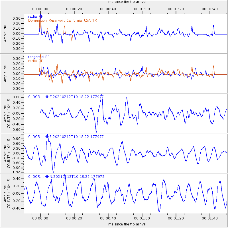
DGR Domenigoni Reservoir, California, USA - Earthquake Result Viewer
*The percent match for this event was below the threshold and hence no stack was calculated.
| Earthquake location: |
Southeast Of Loyalty Islands |
| Earthquake latitude/longitude: |
-23.2/171.6 |
| Earthquake time(UTC): |
2021/02/12 (043) 10:06:01 GMT |
| Earthquake Depth: |
10 km |
| Earthquake Magnitude: |
5.7 mww |
| Earthquake Catalog/Contributor: |
NEIC PDE/us |
|
| Network: |
CI Caltech Regional Seismic Network |
| Station: |
DGR Domenigoni Reservoir, California, USA |
| Lat/Lon: |
33.65 N/117.01 W |
| Elevation: |
609 m |
|
| Distance: |
88.4 deg |
| Az: |
52.279 deg |
| Baz: |
240.735 deg |
| Ray Param: |
$rayparam |
*The percent match for this event was below the threshold and hence was not used in the summary stack. |
|
| Radial Match: |
60.906208 % |
| Radial Bump: |
400 |
| Transverse Match: |
39.441704 % |
| Transverse Bump: |
400 |
| SOD ConfigId: |
23341671 |
| Insert Time: |
2021-02-26 11:12:54.824 +0000 |
| GWidth: |
2.5 |
| Max Bumps: |
400 |
| Tol: |
0.001 |
|
Signal To Noise
| Channel | StoN | STA | LTA |
| CI:DGR: :HHZ:20210212T10:18:22.17797Z | 2.8720086 | 6.040304E-7 | 2.1031636E-7 |
| CI:DGR: :HHN:20210212T10:18:22.17797Z | 0.9238525 | 2.3018988E-7 | 2.49163E-7 |
| CI:DGR: :HHE:20210212T10:18:22.17797Z | 3.0661998 | 2.99323E-7 | 9.762019E-8 |
| Arrivals |
| Ps | |
| PpPs | |
| PsPs/PpSs | |


