You are here: Home > Network List > CI - Caltech Regional Seismic Network Stations List
> Station GMR Granite Mountains Research Center > Earthquake Result Viewer
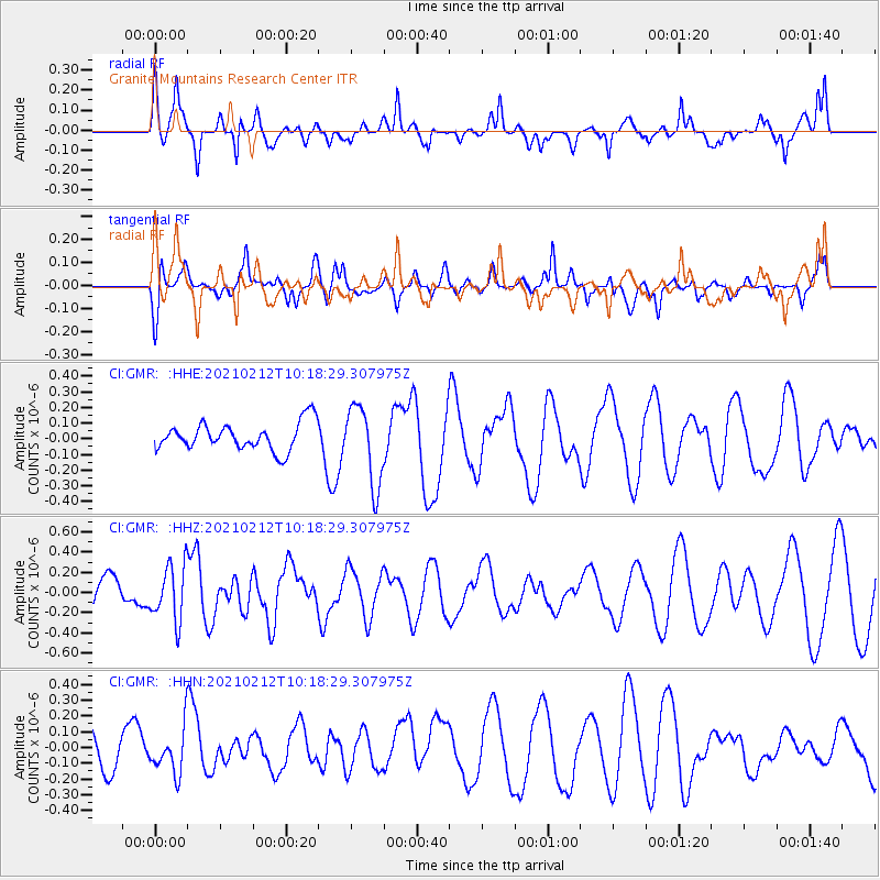
GMR Granite Mountains Research Center - Earthquake Result Viewer
*The percent match for this event was below the threshold and hence no stack was calculated.
| Earthquake location: |
Southeast Of Loyalty Islands |
| Earthquake latitude/longitude: |
-23.2/171.6 |
| Earthquake time(UTC): |
2021/02/12 (043) 10:06:01 GMT |
| Earthquake Depth: |
10 km |
| Earthquake Magnitude: |
5.7 mww |
| Earthquake Catalog/Contributor: |
NEIC PDE/us |
|
| Network: |
CI Caltech Regional Seismic Network |
| Station: |
GMR Granite Mountains Research Center |
| Lat/Lon: |
34.78 N/115.66 W |
| Elevation: |
1326 m |
|
| Distance: |
89.9 deg |
| Az: |
51.829 deg |
| Baz: |
241.484 deg |
| Ray Param: |
$rayparam |
*The percent match for this event was below the threshold and hence was not used in the summary stack. |
|
| Radial Match: |
74.379974 % |
| Radial Bump: |
400 |
| Transverse Match: |
44.08047 % |
| Transverse Bump: |
400 |
| SOD ConfigId: |
23341671 |
| Insert Time: |
2021-02-26 11:13:03.544 +0000 |
| GWidth: |
2.5 |
| Max Bumps: |
400 |
| Tol: |
0.001 |
|
Signal To Noise
| Channel | StoN | STA | LTA |
| CI:GMR: :HHZ:20210212T10:18:29.307975Z | 0.8549615 | 2.7513815E-7 | 3.2181347E-7 |
| CI:GMR: :HHN:20210212T10:18:29.307975Z | 1.0563967 | 1.4444143E-7 | 1.3673028E-7 |
| CI:GMR: :HHE:20210212T10:18:29.307975Z | 2.8535912 | 2.5019878E-7 | 8.7678565E-8 |
| Arrivals |
| Ps | |
| PpPs | |
| PsPs/PpSs | |


