You are here: Home > Network List > CI - Caltech Regional Seismic Network Stations List
> Station IRM Iron Mountain Pumping Station, Eagle Mtn., CA, USA > Earthquake Result Viewer
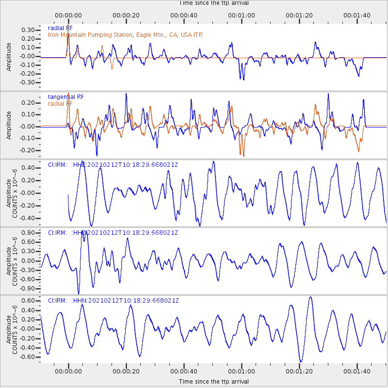
IRM Iron Mountain Pumping Station, Eagle Mtn., CA, USA - Earthquake Result Viewer
*The percent match for this event was below the threshold and hence no stack was calculated.
| Earthquake location: |
Southeast Of Loyalty Islands |
| Earthquake latitude/longitude: |
-23.2/171.6 |
| Earthquake time(UTC): |
2021/02/12 (043) 10:06:01 GMT |
| Earthquake Depth: |
10 km |
| Earthquake Magnitude: |
5.7 mww |
| Earthquake Catalog/Contributor: |
NEIC PDE/us |
|
| Network: |
CI Caltech Regional Seismic Network |
| Station: |
IRM Iron Mountain Pumping Station, Eagle Mtn., CA, USA |
| Lat/Lon: |
34.16 N/115.15 W |
| Elevation: |
567 m |
|
| Distance: |
90.0 deg |
| Az: |
52.581 deg |
| Baz: |
241.774 deg |
| Ray Param: |
$rayparam |
*The percent match for this event was below the threshold and hence was not used in the summary stack. |
|
| Radial Match: |
42.95371 % |
| Radial Bump: |
400 |
| Transverse Match: |
67.809395 % |
| Transverse Bump: |
400 |
| SOD ConfigId: |
23341671 |
| Insert Time: |
2021-02-26 11:13:10.312 +0000 |
| GWidth: |
2.5 |
| Max Bumps: |
400 |
| Tol: |
0.001 |
|
Signal To Noise
| Channel | StoN | STA | LTA |
| CI:IRM: :HHZ:20210212T10:18:29.668021Z | 1.8926342 | 4.7487723E-7 | 2.509081E-7 |
| CI:IRM: :HHN:20210212T10:18:29.668021Z | 0.9360815 | 2.96417E-7 | 3.1665724E-7 |
| CI:IRM: :HHE:20210212T10:18:29.668021Z | 0.73743224 | 1.8304577E-7 | 2.4822046E-7 |
| Arrivals |
| Ps | |
| PpPs | |
| PsPs/PpSs | |


