You are here: Home > Network List > GE - GEOFON Stations List
> Station KSDI GII Station Kfar Sold, Israel > Earthquake Result Viewer
KSDI GII Station Kfar Sold, Israel - Earthquake Result Viewer
| Earthquake location: |
Eastern Siberia, Russia |
| Earthquake latitude/longitude: |
60.9/167.1 |
| Earthquake time(UTC): |
2006/04/20 (110) 23:25:02 GMT |
| Earthquake Depth: |
22 km |
| Earthquake Magnitude: |
6.8 MB, 7.6 MS, 7.6 MW, 7.3 MW |
| Earthquake Catalog/Contributor: |
WHDF/NEIC |
|
| Network: |
GE GEOFON |
| Station: |
KSDI GII Station Kfar Sold, Israel |
| Lat/Lon: |
33.19 N/35.66 E |
| Elevation: |
123 m |
|
| Distance: |
78.2 deg |
| Az: |
320.037 deg |
| Baz: |
21.954 deg |
| Ray Param: |
0.049790934 |
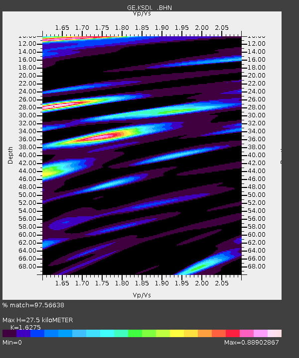
| Estimated Moho Depth: |
27.5 km |
| Estimated Crust Vp/Vs: |
1.63 |
| Assumed Crust Vp: |
5.738 km/s |
| Estimated Crust Vs: |
3.526 km/s |
| Estimated Crust Poisson's Ratio: |
0.20 |
|
| Radial Match: |
97.56638 % |
| Radial Bump: |
400 |
| Transverse Match: |
94.619286 % |
| Transverse Bump: |
400 |
| SOD ConfigId: |
2669 |
| Insert Time: |
2010-03-09 05:25:11.197 +0000 |
| GWidth: |
2.5 |
| Max Bumps: |
400 |
| Tol: |
0.001 |
|

Signal To Noise
| Channel | StoN | STA | LTA |
| GE:KSDI: :BHN:20060420T23:36:28.496008Z | 42.54382 | 2.5786653E-6 | 6.061198E-8 |
| GE:KSDI: :BHE:20060420T23:36:28.472021Z | 15.410371 | 1.163511E-6 | 7.5501816E-8 |
| GE:KSDI: :BHZ:20060420T23:36:28.496008Z | 44.142437 | 7.161797E-6 | 1.622429E-7 |
| Arrivals |
| Ps | 3.1 SECOND |
| PpPs | 12 SECOND |
| PsPs/PpSs | 15 SECOND |


