You are here: Home > Network List > WY - Yellowstone Wyoming Seismic Network Stations List
> Station YEE East Entrance, YNP, WY, USA > Earthquake Result Viewer
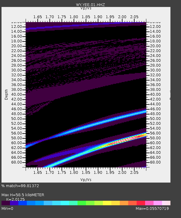
YEE East Entrance, YNP, WY, USA - Earthquake Result Viewer
| Earthquake location: |
Southeast Of Loyalty Islands |
| Earthquake latitude/longitude: |
-23.2/171.6 |
| Earthquake time(UTC): |
2021/02/12 (043) 10:06:01 GMT |
| Earthquake Depth: |
10 km |
| Earthquake Magnitude: |
5.7 mww |
| Earthquake Catalog/Contributor: |
NEIC PDE/us |
|
| Network: |
WY Yellowstone Wyoming Seismic Network |
| Station: |
YEE East Entrance, YNP, WY, USA |
| Lat/Lon: |
44.49 N/109.90 W |
| Elevation: |
2270 m |
|
| Distance: |
98.2 deg |
| Az: |
45.135 deg |
| Baz: |
245.636 deg |
| Ray Param: |
0.039972927 |
| Estimated Moho Depth: |
58.5 km |
| Estimated Crust Vp/Vs: |
2.01 |
| Assumed Crust Vp: |
6.242 km/s |
| Estimated Crust Vs: |
3.102 km/s |
| Estimated Crust Poisson's Ratio: |
0.34 |
|
| Radial Match: |
99.81372 % |
| Radial Bump: |
33 |
| Transverse Match: |
94.808014 % |
| Transverse Bump: |
318 |
| SOD ConfigId: |
23341671 |
| Insert Time: |
2021-02-26 11:20:35.447 +0000 |
| GWidth: |
2.5 |
| Max Bumps: |
400 |
| Tol: |
0.001 |
|

Signal To Noise
| Channel | StoN | STA | LTA |
| WY:YEE:01:HHZ:20210212T10:19:07.150016Z | 0.8209685 | 2.2166918E-7 | 2.7000934E-7 |
| WY:YEE:01:HHN:20210212T10:19:07.150016Z | 0.7855842 | 5.0629986E-8 | 6.444883E-8 |
| WY:YEE:01:HHE:20210212T10:19:07.150016Z | 0.8054964 | 2.178159E-7 | 2.7041202E-7 |
| Arrivals |
| Ps | 9.6 SECOND |
| PpPs | 28 SECOND |
| PsPs/PpSs | 37 SECOND |


