You are here: Home > Network List > WY - Yellowstone Wyoming Seismic Network Stations List
> Station YHH Holmes Hill, YNP, WY, USA > Earthquake Result Viewer
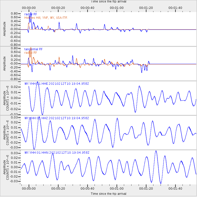
YHH Holmes Hill, YNP, WY, USA - Earthquake Result Viewer
*The percent match for this event was below the threshold and hence no stack was calculated.
| Earthquake location: |
Southeast Of Loyalty Islands |
| Earthquake latitude/longitude: |
-23.2/171.6 |
| Earthquake time(UTC): |
2021/02/12 (043) 10:06:01 GMT |
| Earthquake Depth: |
10 km |
| Earthquake Magnitude: |
5.7 mww |
| Earthquake Catalog/Contributor: |
NEIC PDE/us |
|
| Network: |
WY Yellowstone Wyoming Seismic Network |
| Station: |
YHH Holmes Hill, YNP, WY, USA |
| Lat/Lon: |
44.79 N/110.85 W |
| Elevation: |
2717 m |
|
| Distance: |
97.7 deg |
| Az: |
44.57 deg |
| Baz: |
245.047 deg |
| Ray Param: |
$rayparam |
*The percent match for this event was below the threshold and hence was not used in the summary stack. |
|
| Radial Match: |
75.12286 % |
| Radial Bump: |
400 |
| Transverse Match: |
76.73536 % |
| Transverse Bump: |
394 |
| SOD ConfigId: |
23341671 |
| Insert Time: |
2021-02-26 11:20:38.537 +0000 |
| GWidth: |
2.5 |
| Max Bumps: |
400 |
| Tol: |
0.001 |
|
Signal To Noise
| Channel | StoN | STA | LTA |
| WY:YHH:01:HHZ:20210212T10:19:04.958Z | 3.3020747 | 2.2810047E-8 | 6.9077926E-9 |
| WY:YHH:01:HHN:20210212T10:19:04.958Z | 1.7046027 | 1.0268657E-8 | 6.0240763E-9 |
| WY:YHH:01:HHE:20210212T10:19:04.958Z | 0.75841135 | 1.1795434E-8 | 1.5552818E-8 |
| Arrivals |
| Ps | |
| PpPs | |
| PsPs/PpSs | |


