You are here: Home > Network List > GE - GEOFON Stations List
> Station KSDI GII Station Kfar Sold, Israel > Earthquake Result Viewer
KSDI GII Station Kfar Sold, Israel - Earthquake Result Viewer
| Earthquake location: |
Ryukyu Islands, Japan |
| Earthquake latitude/longitude: |
28.6/129.9 |
| Earthquake time(UTC): |
2006/11/17 (321) 18:03:12 GMT |
| Earthquake Depth: |
22 km |
| Earthquake Magnitude: |
5.8 MB, 5.8 MS, 6.2 MW, 6.1 MW |
| Earthquake Catalog/Contributor: |
WHDF/NEIC |
|
| Network: |
GE GEOFON |
| Station: |
KSDI GII Station Kfar Sold, Israel |
| Lat/Lon: |
33.19 N/35.66 E |
| Elevation: |
123 m |
|
| Distance: |
78.2 deg |
| Az: |
301.311 deg |
| Baz: |
63.639 deg |
| Ray Param: |
0.049798302 |
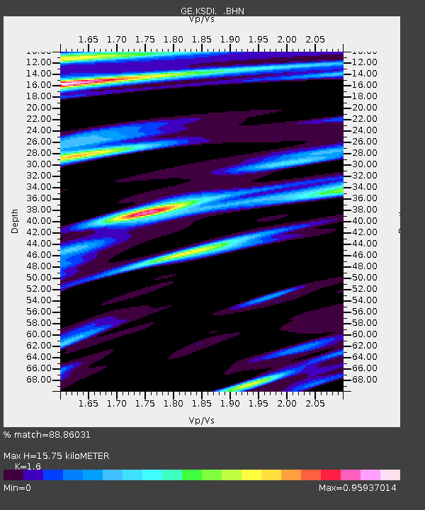
| Estimated Moho Depth: |
15.75 km |
| Estimated Crust Vp/Vs: |
1.60 |
| Assumed Crust Vp: |
5.738 km/s |
| Estimated Crust Vs: |
3.586 km/s |
| Estimated Crust Poisson's Ratio: |
0.18 |
|
| Radial Match: |
88.86031 % |
| Radial Bump: |
400 |
| Transverse Match: |
86.02367 % |
| Transverse Bump: |
400 |
| SOD ConfigId: |
2564 |
| Insert Time: |
2010-03-09 05:25:20.898 +0000 |
| GWidth: |
2.5 |
| Max Bumps: |
400 |
| Tol: |
0.001 |
|

Signal To Noise
| Channel | StoN | STA | LTA |
| GE:KSDI: :BHN:20061117T18:14:38.536001Z | 2.3270414 | 1.8584643E-7 | 7.986383E-8 |
| GE:KSDI: :BHE:20061117T18:14:38.536001Z | 3.074946 | 2.1941925E-7 | 7.135711E-8 |
| GE:KSDI: :BHZ:20061117T18:14:38.536001Z | 8.807502 | 8.5235246E-7 | 9.6775736E-8 |
| Arrivals |
| Ps | 1.7 SECOND |
| PpPs | 7.0 SECOND |
| PsPs/PpSs | 8.6 SECOND |


