You are here: Home > Network List > GE - GEOFON Stations List
> Station KSDI GII Station Kfar Sold, Israel > Earthquake Result Viewer
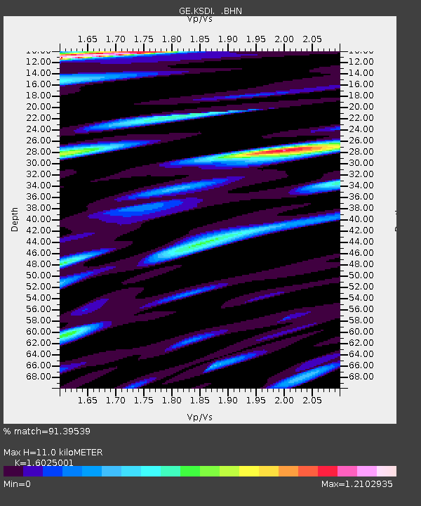
KSDI GII Station Kfar Sold, Israel - Earthquake Result Viewer
| Earthquake location: |
Kuril Islands |
| Earthquake latitude/longitude: |
47.3/154.1 |
| Earthquake time(UTC): |
2006/11/15 (319) 21:22:21 GMT |
| Earthquake Depth: |
12 km |
| Earthquake Magnitude: |
6.0 MB, 5.8 MS, 5.9 MW, 6.1 ME |
| Earthquake Catalog/Contributor: |
WHDF/NEIC |
|
| Network: |
GE GEOFON |
| Station: |
KSDI GII Station Kfar Sold, Israel |
| Lat/Lon: |
33.19 N/35.66 E |
| Elevation: |
123 m |
|
| Distance: |
82.7 deg |
| Az: |
312.014 deg |
| Baz: |
37.108 deg |
| Ray Param: |
0.04668854 |
| Estimated Moho Depth: |
11.0 km |
| Estimated Crust Vp/Vs: |
1.60 |
| Assumed Crust Vp: |
5.738 km/s |
| Estimated Crust Vs: |
3.581 km/s |
| Estimated Crust Poisson's Ratio: |
0.18 |
|
| Radial Match: |
91.39539 % |
| Radial Bump: |
400 |
| Transverse Match: |
88.24444 % |
| Transverse Bump: |
400 |
| SOD ConfigId: |
2564 |
| Insert Time: |
2010-03-09 05:25:23.525 +0000 |
| GWidth: |
2.5 |
| Max Bumps: |
400 |
| Tol: |
0.001 |
|

Signal To Noise
| Channel | StoN | STA | LTA |
| GE:KSDI: :BHN:20061115T21:34:13.537026Z | 4.1596313 | 7.0915604E-7 | 1.7048531E-7 |
| GE:KSDI: :BHE:20061115T21:34:13.537026Z | 6.122737 | 8.6421574E-7 | 1.4114859E-7 |
| GE:KSDI: :BHZ:20061115T21:34:13.537026Z | 16.00291 | 2.8281138E-6 | 1.7672497E-7 |
| Arrivals |
| Ps | 1.2 SECOND |
| PpPs | 4.9 SECOND |
| PsPs/PpSs | 6.1 SECOND |


