You are here: Home > Network List > GE - GEOFON Stations List
> Station KSDI GII Station Kfar Sold, Israel > Earthquake Result Viewer
KSDI GII Station Kfar Sold, Israel - Earthquake Result Viewer
| Earthquake location: |
Kuril Islands |
| Earthquake latitude/longitude: |
47.1/154.4 |
| Earthquake time(UTC): |
2006/11/15 (319) 12:16:05 GMT |
| Earthquake Depth: |
10 km |
| Earthquake Magnitude: |
5.7 MB |
| Earthquake Catalog/Contributor: |
WHDF/NEIC |
|
| Network: |
GE GEOFON |
| Station: |
KSDI GII Station Kfar Sold, Israel |
| Lat/Lon: |
33.19 N/35.66 E |
| Elevation: |
123 m |
|
| Distance: |
83.0 deg |
| Az: |
312.212 deg |
| Baz: |
37.108 deg |
| Ray Param: |
0.046518866 |
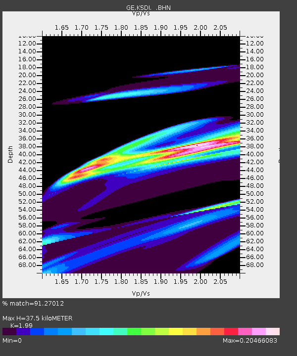
| Estimated Moho Depth: |
37.5 km |
| Estimated Crust Vp/Vs: |
1.99 |
| Assumed Crust Vp: |
5.738 km/s |
| Estimated Crust Vs: |
2.884 km/s |
| Estimated Crust Poisson's Ratio: |
0.33 |
|
| Radial Match: |
91.27012 % |
| Radial Bump: |
372 |
| Transverse Match: |
89.13853 % |
| Transverse Bump: |
389 |
| SOD ConfigId: |
2564 |
| Insert Time: |
2010-03-09 05:25:24.744 +0000 |
| GWidth: |
2.5 |
| Max Bumps: |
400 |
| Tol: |
0.001 |
|

Signal To Noise
| Channel | StoN | STA | LTA |
| GE:KSDI: :BHN:20061115T12:27:59.237021Z | 1.0341483 | 5.0104565E-5 | 4.8450078E-5 |
| GE:KSDI: :BHE:20061115T12:27:59.237021Z | 1.5455248 | 2.2718254E-5 | 1.4699377E-5 |
| GE:KSDI: :BHZ:20061115T12:27:59.237021Z | 1.3727643 | 1.2453909E-4 | 9.072139E-5 |
| Arrivals |
| Ps | 6.6 SECOND |
| PpPs | 19 SECOND |
| PsPs/PpSs | 26 SECOND |


