You are here: Home > Network List > GE - GEOFON Stations List
> Station KSDI GII Station Kfar Sold, Israel > Earthquake Result Viewer
KSDI GII Station Kfar Sold, Israel - Earthquake Result Viewer
| Earthquake location: |
Kuril Islands |
| Earthquake latitude/longitude: |
46.5/153.4 |
| Earthquake time(UTC): |
2006/09/28 (271) 01:36:48 GMT |
| Earthquake Depth: |
11 km |
| Earthquake Magnitude: |
5.8 MB, 5.5 MS, 5.9 MW, 5.9 MW |
| Earthquake Catalog/Contributor: |
WHDF/NEIC |
|
| Network: |
GE GEOFON |
| Station: |
KSDI GII Station Kfar Sold, Israel |
| Lat/Lon: |
33.19 N/35.66 E |
| Elevation: |
123 m |
|
| Distance: |
82.9 deg |
| Az: |
311.564 deg |
| Baz: |
38.084 deg |
| Ray Param: |
0.046591662 |
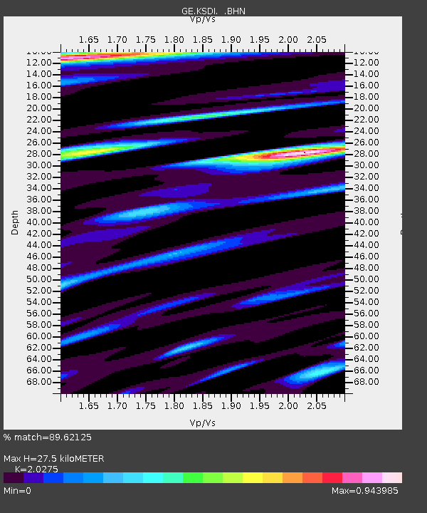
| Estimated Moho Depth: |
27.5 km |
| Estimated Crust Vp/Vs: |
2.03 |
| Assumed Crust Vp: |
5.738 km/s |
| Estimated Crust Vs: |
2.83 km/s |
| Estimated Crust Poisson's Ratio: |
0.34 |
|
| Radial Match: |
89.62125 % |
| Radial Bump: |
400 |
| Transverse Match: |
92.02315 % |
| Transverse Bump: |
400 |
| SOD ConfigId: |
2665 |
| Insert Time: |
2010-03-09 05:25:34.857 +0000 |
| GWidth: |
2.5 |
| Max Bumps: |
400 |
| Tol: |
0.001 |
|

Signal To Noise
| Channel | StoN | STA | LTA |
| GE:KSDI: :BHN:20060928T01:48:41.285017Z | 2.3055992 | 2.2079186E-7 | 9.576333E-8 |
| GE:KSDI: :BHE:20060928T01:48:41.285017Z | 2.217836 | 2.4896886E-7 | 1.1225757E-7 |
| GE:KSDI: :BHZ:20060928T01:48:41.285017Z | 8.752332 | 9.467122E-7 | 1.0816686E-7 |
| Arrivals |
| Ps | 5.0 SECOND |
| PpPs | 14 SECOND |
| PsPs/PpSs | 19 SECOND |


