You are here: Home > Network List > GE - GEOFON Stations List
> Station KSDI GII Station Kfar Sold, Israel > Earthquake Result Viewer
KSDI GII Station Kfar Sold, Israel - Earthquake Result Viewer
| Earthquake location: |
Flores Sea |
| Earthquake latitude/longitude: |
-7.2/120.1 |
| Earthquake time(UTC): |
2006/09/09 (252) 04:13:12 GMT |
| Earthquake Depth: |
572 km |
| Earthquake Magnitude: |
6.0 MB, 6.3 MW, 6.3 MW |
| Earthquake Catalog/Contributor: |
WHDF/NEIC |
|
| Network: |
GE GEOFON |
| Station: |
KSDI GII Station Kfar Sold, Israel |
| Lat/Lon: |
33.19 N/35.66 E |
| Elevation: |
123 m |
|
| Distance: |
89.3 deg |
| Az: |
303.421 deg |
| Baz: |
99.027 deg |
| Ray Param: |
0.041600157 |
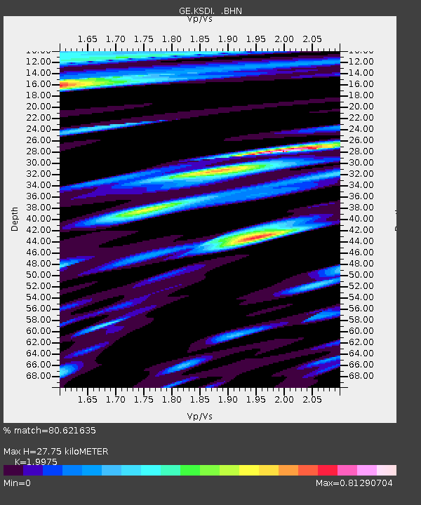
| Estimated Moho Depth: |
27.75 km |
| Estimated Crust Vp/Vs: |
2.00 |
| Assumed Crust Vp: |
5.738 km/s |
| Estimated Crust Vs: |
2.873 km/s |
| Estimated Crust Poisson's Ratio: |
0.33 |
|
| Radial Match: |
80.621635 % |
| Radial Bump: |
400 |
| Transverse Match: |
75.06955 % |
| Transverse Bump: |
400 |
| SOD ConfigId: |
2665 |
| Insert Time: |
2010-03-09 05:25:37.912 +0000 |
| GWidth: |
2.5 |
| Max Bumps: |
400 |
| Tol: |
0.001 |
|

Signal To Noise
| Channel | StoN | STA | LTA |
| GE:KSDI: :BHN:20060909T04:24:36.485017Z | 1.8028963 | 1.0377411E-7 | 5.755967E-8 |
| GE:KSDI: :BHE:20060909T04:24:36.485017Z | 2.7402267 | 1.598281E-7 | 5.8326602E-8 |
| GE:KSDI: :BHZ:20060909T04:24:36.485017Z | 6.896286 | 5.260916E-7 | 7.628621E-8 |
| Arrivals |
| Ps | 4.9 SECOND |
| PpPs | 14 SECOND |
| PsPs/PpSs | 19 SECOND |


