You are here: Home > Network List > GE - GEOFON Stations List
> Station KSDI GII Station Kfar Sold, Israel > Earthquake Result Viewer
KSDI GII Station Kfar Sold, Israel - Earthquake Result Viewer
| Earthquake location: |
Northwest Of Kuril Islands |
| Earthquake latitude/longitude: |
47.8/146.2 |
| Earthquake time(UTC): |
2002/11/17 (321) 04:53:53 GMT |
| Earthquake Depth: |
459 km |
| Earthquake Magnitude: |
7.3 MW, 7.3 MW |
| Earthquake Catalog/Contributor: |
WHDF/NEIC |
|
| Network: |
GE GEOFON |
| Station: |
KSDI GII Station Kfar Sold, Israel |
| Lat/Lon: |
33.19 N/35.66 E |
| Elevation: |
123 m |
|
| Distance: |
78.2 deg |
| Az: |
306.672 deg |
| Baz: |
40.135 deg |
| Ray Param: |
0.04844733 |
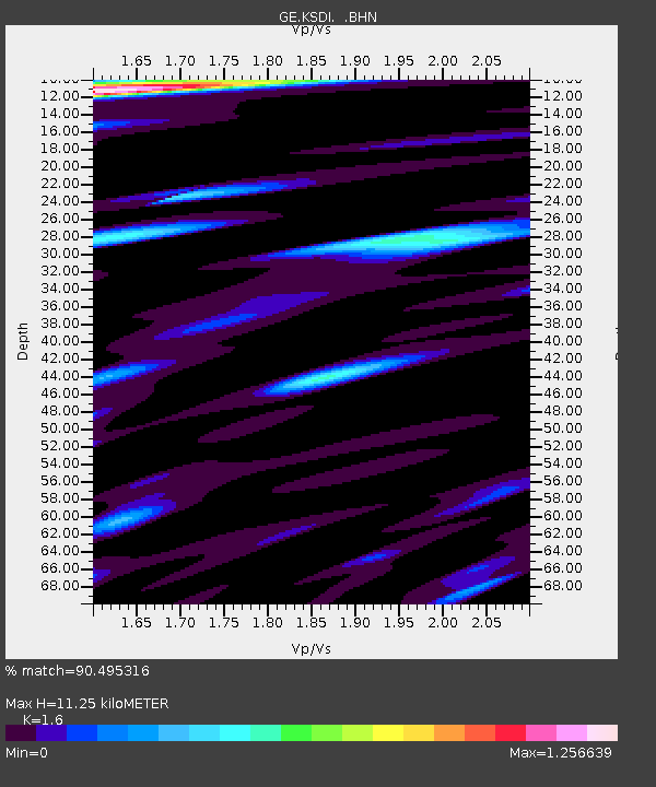
| Estimated Moho Depth: |
11.25 km |
| Estimated Crust Vp/Vs: |
1.60 |
| Assumed Crust Vp: |
5.738 km/s |
| Estimated Crust Vs: |
3.586 km/s |
| Estimated Crust Poisson's Ratio: |
0.18 |
|
| Radial Match: |
90.495316 % |
| Radial Bump: |
400 |
| Transverse Match: |
83.86077 % |
| Transverse Bump: |
400 |
| SOD ConfigId: |
4714 |
| Insert Time: |
2010-03-09 05:25:53.260 +0000 |
| GWidth: |
2.5 |
| Max Bumps: |
400 |
| Tol: |
0.001 |
|

Signal To Noise
| Channel | StoN | STA | LTA |
| GE:KSDI: :BHN:20021117T05:04:33.495994Z | 33.412563 | 3.829199E-6 | 1.1460357E-7 |
| GE:KSDI: :BHE:20021117T05:04:33.472007Z | 32.94911 | 4.500515E-6 | 1.3658989E-7 |
| GE:KSDI: :BHZ:20021117T05:04:33.495994Z | 97.557175 | 1.889764E-5 | 1.9370835E-7 |
| Arrivals |
| Ps | 1.2 SECOND |
| PpPs | 5.0 SECOND |
| PsPs/PpSs | 6.2 SECOND |


