You are here: Home > Network List > G - GEOSCOPE Stations List
> Station INU Inuyama, Japan > Earthquake Result Viewer
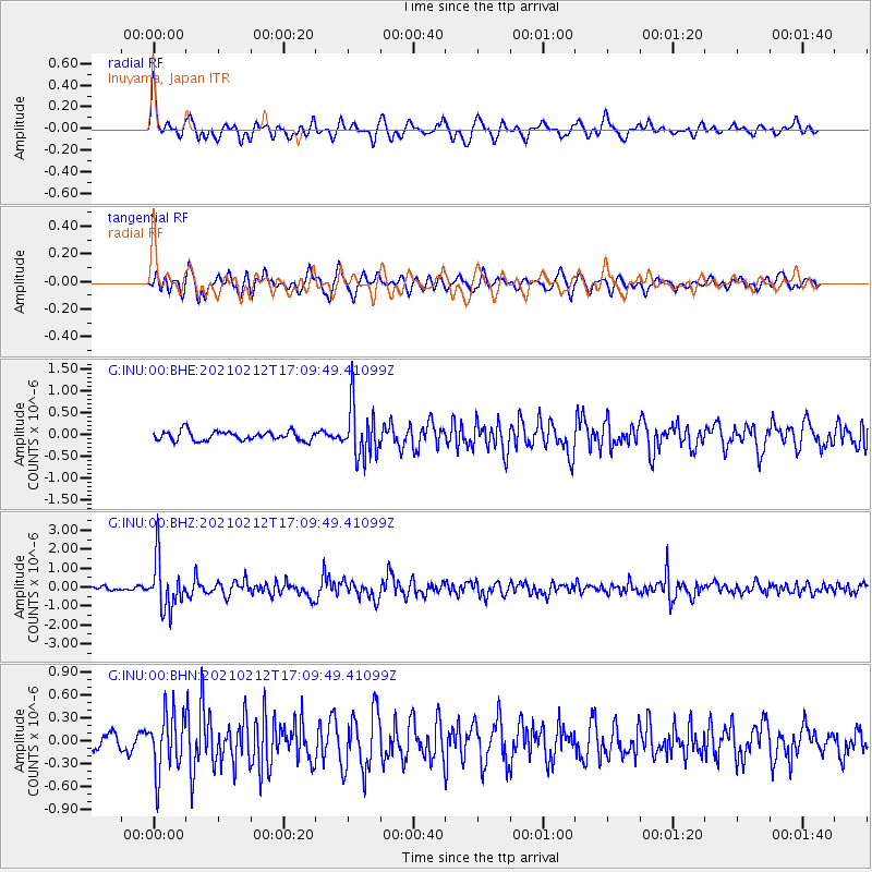
INU Inuyama, Japan - Earthquake Result Viewer
*The percent match for this event was below the threshold and hence no stack was calculated.
| Earthquake location: |
Tajikistan-Xinjiang Border Reg. |
| Earthquake latitude/longitude: |
38.1/73.6 |
| Earthquake time(UTC): |
2021/02/12 (043) 17:01:34 GMT |
| Earthquake Depth: |
92 km |
| Earthquake Magnitude: |
5.9 Mww |
| Earthquake Catalog/Contributor: |
NEIC PDE/us |
|
| Network: |
G GEOSCOPE |
| Station: |
INU Inuyama, Japan |
| Lat/Lon: |
35.35 N/137.03 E |
| Elevation: |
132 m |
|
| Distance: |
50.0 deg |
| Az: |
72.568 deg |
| Baz: |
293.016 deg |
| Ray Param: |
$rayparam |
*The percent match for this event was below the threshold and hence was not used in the summary stack. |
|
| Radial Match: |
78.86154 % |
| Radial Bump: |
400 |
| Transverse Match: |
80.62626 % |
| Transverse Bump: |
400 |
| SOD ConfigId: |
23341671 |
| Insert Time: |
2021-02-26 18:10:13.020 +0000 |
| GWidth: |
2.5 |
| Max Bumps: |
400 |
| Tol: |
0.001 |
|
Signal To Noise
| Channel | StoN | STA | LTA |
| G:INU:00:BHZ:20210212T17:09:49.41099Z | 12.783232 | 1.307421E-6 | 1.0227626E-7 |
| G:INU:00:BHN:20210212T17:09:49.41099Z | 3.590388 | 3.8473698E-7 | 1.071575E-7 |
| G:INU:00:BHE:20210212T17:09:49.41099Z | 5.64398 | 5.976995E-7 | 1.05900355E-7 |
| Arrivals |
| Ps | |
| PpPs | |
| PsPs/PpSs | |


