You are here: Home > Network List > GE - GEOFON Stations List
> Station KSDI GII Station Kfar Sold, Israel > Earthquake Result Viewer
KSDI GII Station Kfar Sold, Israel - Earthquake Result Viewer
| Earthquake location: |
Nicobar Islands, India Region |
| Earthquake latitude/longitude: |
6.0/94.4 |
| Earthquake time(UTC): |
2002/10/24 (297) 21:53:43 GMT |
| Earthquake Depth: |
65 km |
| Earthquake Magnitude: |
6.2 MB, 5.7 MW, 5.7 MW |
| Earthquake Catalog/Contributor: |
WHDF/NEIC |
|
| Network: |
GE GEOFON |
| Station: |
KSDI GII Station Kfar Sold, Israel |
| Lat/Lon: |
33.19 N/35.66 E |
| Elevation: |
123 m |
|
| Distance: |
60.7 deg |
| Az: |
304.705 deg |
| Baz: |
102.822 deg |
| Ray Param: |
0.06119523 |
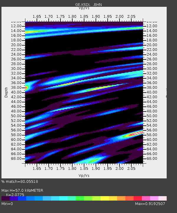
| Estimated Moho Depth: |
57.0 km |
| Estimated Crust Vp/Vs: |
2.08 |
| Assumed Crust Vp: |
5.738 km/s |
| Estimated Crust Vs: |
2.762 km/s |
| Estimated Crust Poisson's Ratio: |
0.35 |
|
| Radial Match: |
80.05518 % |
| Radial Bump: |
400 |
| Transverse Match: |
84.41523 % |
| Transverse Bump: |
400 |
| SOD ConfigId: |
4714 |
| Insert Time: |
2010-03-09 05:26:10.770 +0000 |
| GWidth: |
2.5 |
| Max Bumps: |
400 |
| Tol: |
0.001 |
|

Signal To Noise
| Channel | StoN | STA | LTA |
| GE:KSDI: :BHN:20021024T22:03:17.197019Z | 1.0393823 | 1.0879072E-7 | 1.0466863E-7 |
| GE:KSDI: :BHE:20021024T22:03:17.197019Z | 3.0152118 | 2.9109677E-7 | 9.654273E-8 |
| GE:KSDI: :BHZ:20021024T22:03:17.197019Z | 8.59891 | 9.205999E-7 | 1.0706006E-7 |
| Arrivals |
| Ps | 11 SECOND |
| PpPs | 30 SECOND |
| PsPs/PpSs | 41 SECOND |


