You are here: Home > Network List > GE - GEOFON Stations List
> Station KSDI GII Station Kfar Sold, Israel > Earthquake Result Viewer
KSDI GII Station Kfar Sold, Israel - Earthquake Result Viewer
| Earthquake location: |
Taiwan |
| Earthquake latitude/longitude: |
23.5/121.6 |
| Earthquake time(UTC): |
2003/06/10 (161) 08:40:30 GMT |
| Earthquake Depth: |
44 km |
| Earthquake Magnitude: |
5.8 MB, 5.7 MS, 6.0 MW, 5.9 MW |
| Earthquake Catalog/Contributor: |
WHDF/NEIC |
|
| Network: |
GE GEOFON |
| Station: |
KSDI GII Station Kfar Sold, Israel |
| Lat/Lon: |
33.19 N/35.66 E |
| Elevation: |
123 m |
|
| Distance: |
74.3 deg |
| Az: |
299.682 deg |
| Baz: |
71.996 deg |
| Ray Param: |
0.052335616 |
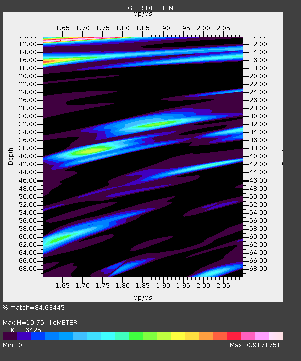
| Estimated Moho Depth: |
10.75 km |
| Estimated Crust Vp/Vs: |
1.64 |
| Assumed Crust Vp: |
5.738 km/s |
| Estimated Crust Vs: |
3.494 km/s |
| Estimated Crust Poisson's Ratio: |
0.21 |
|
| Radial Match: |
84.63445 % |
| Radial Bump: |
400 |
| Transverse Match: |
80.63862 % |
| Transverse Bump: |
400 |
| SOD ConfigId: |
4714 |
| Insert Time: |
2010-03-09 05:26:13.140 +0000 |
| GWidth: |
2.5 |
| Max Bumps: |
400 |
| Tol: |
0.001 |
|

Signal To Noise
| Channel | StoN | STA | LTA |
| GE:KSDI: :BHN:20030610T08:51:32.702009Z | 1.6731869 | 1.222651E-7 | 7.3073195E-8 |
| GE:KSDI: :BHE:20030610T08:51:32.678022Z | 2.626622 | 2.2921E-7 | 8.7264176E-8 |
| GE:KSDI: :BHZ:20030610T08:51:32.678022Z | 9.347944 | 9.382977E-7 | 1.0037476E-7 |
| Arrivals |
| Ps | 1.2 SECOND |
| PpPs | 4.8 SECOND |
| PsPs/PpSs | 6.1 SECOND |


