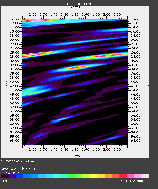
KSDI GII Station Kfar Sold, Israel - Earthquake Result Viewer

Earthquake location: Rat Islands, Aleutian Islands
Earthquake latitude/longitude: 51.3/178.0
Earthquake time(UTC): 2003/03/17 (076) 16:36:17 GMT
Earthquake Depth: 33 km
Earthquake Magnitude: 5.9 MB, 6.7 MS, 7.0 MW, 7.0 MW
Earthquake Catalog/Contributor: WHDF/NEIC
Network: GE GEOFON
Station: KSDI GII Station Kfar Sold, Israel
Lat/Lon: 33.19 N/35.66 E
Elevation: 123 m
Distance: 89.6 deg
Az: 329.165 deg
Baz: 22.581 deg
Ray Param: 0.041729532
Estimated Moho Depth: 27.0 km
Estimated Crust Vp/Vs: 1.63
Assumed Crust Vp: 5.738 km/s
Estimated Crust Vs: 3.51 km/s
Estimated Crust Poisson's Ratio: 0.20
Radial Match: 94.27464 %
Radial Bump: 400
Transverse Match: 91.76195 %
Transverse Bump: 400
SOD ConfigId: 4714
Insert Time: 2010-03-09 05:26:17.364 +0000
GWidth: 2.5
Max Bumps: 400
Tol: 0.001

Signal To Noise

ChannelStoNSTALTA
GE:KSDI: :BHN:20030317T16:48:40.302004Z1.58674483.338736E-82.1041416E-8
GE:KSDI: :BHE:20030317T16:48:40.302004Z2.97474627.7144364E-82.5933092E-8
GE:KSDI: :BHZ:20030317T16:48:40.302004Z7.67201332.0316585E-72.6481427E-8
Arrivals
Ps3.0 SECOND
PpPs12 SECOND
PsPs/PpSs15 SECOND