You are here: Home > Network List > GE - GEOFON Stations List
> Station KSDI GII Station Kfar Sold, Israel > Earthquake Result Viewer
KSDI GII Station Kfar Sold, Israel - Earthquake Result Viewer
| Earthquake location: |
East Of Kuril Islands |
| Earthquake latitude/longitude: |
48.8/156.3 |
| Earthquake time(UTC): |
2004/12/18 (353) 06:46:19 GMT |
| Earthquake Depth: |
11 km |
| Earthquake Magnitude: |
5.5 MB, 6.1 MS, 6.2 MW, 6.1 MW |
| Earthquake Catalog/Contributor: |
WHDF/NEIC |
|
| Network: |
GE GEOFON |
| Station: |
KSDI GII Station Kfar Sold, Israel |
| Lat/Lon: |
33.19 N/35.66 E |
| Elevation: |
123 m |
|
| Distance: |
82.7 deg |
| Az: |
313.346 deg |
| Baz: |
34.961 deg |
| Ray Param: |
0.046683803 |
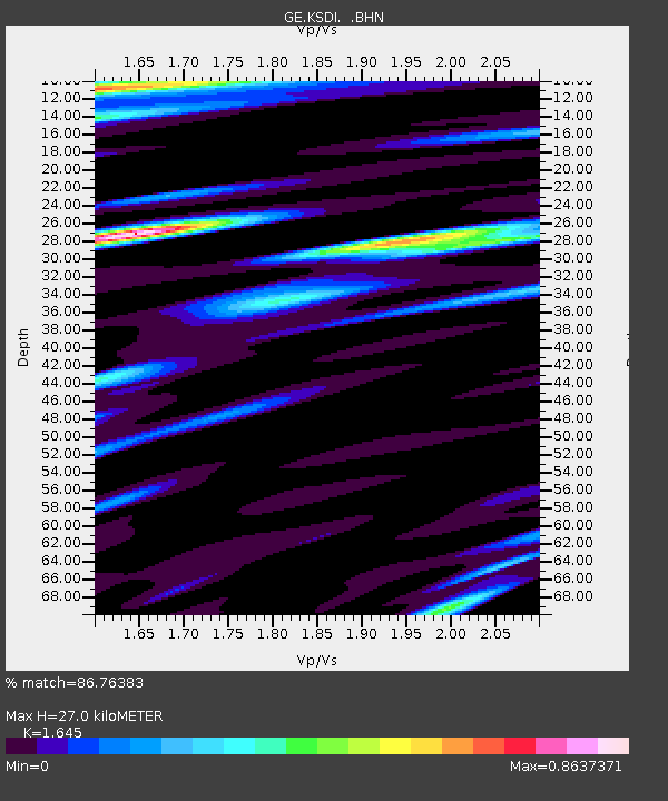
| Estimated Moho Depth: |
27.0 km |
| Estimated Crust Vp/Vs: |
1.64 |
| Assumed Crust Vp: |
5.738 km/s |
| Estimated Crust Vs: |
3.488 km/s |
| Estimated Crust Poisson's Ratio: |
0.21 |
|
| Radial Match: |
86.76383 % |
| Radial Bump: |
400 |
| Transverse Match: |
85.68861 % |
| Transverse Bump: |
400 |
| SOD ConfigId: |
2459 |
| Insert Time: |
2010-03-09 05:26:22.299 +0000 |
| GWidth: |
2.5 |
| Max Bumps: |
400 |
| Tol: |
0.001 |
|

Signal To Noise
| Channel | StoN | STA | LTA |
| GE:KSDI: :BHN:20041218T06:58:12.15302Z | 2.6646516 | 3.2244253E-7 | 1.2100739E-7 |
| GE:KSDI: :BHE:20041218T06:58:12.127996Z | 1.3721849 | 2.049995E-7 | 1.4939641E-7 |
| GE:KSDI: :BHZ:20041218T06:58:12.127996Z | 7.569804 | 1.0174005E-6 | 1.3440248E-7 |
| Arrivals |
| Ps | 3.1 SECOND |
| PpPs | 12 SECOND |
| PsPs/PpSs | 15 SECOND |


