You are here: Home > Network List > TA - USArray Transportable Network (new EarthScope stations) Stations List
> Station E20K Nigu River, AK, USA > Earthquake Result Viewer
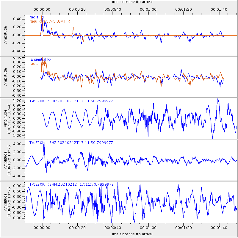
E20K Nigu River, AK, USA - Earthquake Result Viewer
*The percent match for this event was below the threshold and hence no stack was calculated.
| Earthquake location: |
Tajikistan-Xinjiang Border Reg. |
| Earthquake latitude/longitude: |
38.1/73.6 |
| Earthquake time(UTC): |
2021/02/12 (043) 17:01:34 GMT |
| Earthquake Depth: |
92 km |
| Earthquake Magnitude: |
5.9 Mww |
| Earthquake Catalog/Contributor: |
NEIC PDE/us |
|
| Network: |
TA USArray Transportable Network (new EarthScope stations) |
| Station: |
E20K Nigu River, AK, USA |
| Lat/Lon: |
68.26 N/156.19 W |
| Elevation: |
866 m |
|
| Distance: |
67.6 deg |
| Az: |
17.913 deg |
| Baz: |
319.383 deg |
| Ray Param: |
$rayparam |
*The percent match for this event was below the threshold and hence was not used in the summary stack. |
|
| Radial Match: |
76.88065 % |
| Radial Bump: |
400 |
| Transverse Match: |
72.21371 % |
| Transverse Bump: |
400 |
| SOD ConfigId: |
23341671 |
| Insert Time: |
2021-02-26 18:15:18.928 +0000 |
| GWidth: |
2.5 |
| Max Bumps: |
400 |
| Tol: |
0.001 |
|
Signal To Noise
| Channel | StoN | STA | LTA |
| TA:E20K: :BHZ:20210212T17:11:50.799997Z | 1.8268491 | 1.6277495E-6 | 8.9101474E-7 |
| TA:E20K: :BHN:20210212T17:11:50.799997Z | 0.83823186 | 5.10331E-7 | 6.088185E-7 |
| TA:E20K: :BHE:20210212T17:11:50.799997Z | 1.0657985 | 4.5213292E-7 | 4.242199E-7 |
| Arrivals |
| Ps | |
| PpPs | |
| PsPs/PpSs | |


