You are here: Home > Network List > TA - USArray Transportable Network (new EarthScope stations) Stations List
> Station F14K Arctic Creek, AK, USA > Earthquake Result Viewer
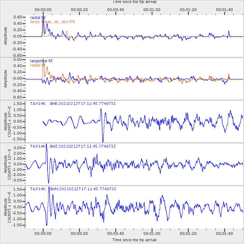
F14K Arctic Creek, AK, USA - Earthquake Result Viewer
*The percent match for this event was below the threshold and hence no stack was calculated.
| Earthquake location: |
Tajikistan-Xinjiang Border Reg. |
| Earthquake latitude/longitude: |
38.1/73.6 |
| Earthquake time(UTC): |
2021/02/12 (043) 17:01:34 GMT |
| Earthquake Depth: |
92 km |
| Earthquake Magnitude: |
5.9 Mww |
| Earthquake Catalog/Contributor: |
NEIC PDE/us |
|
| Network: |
TA USArray Transportable Network (new EarthScope stations) |
| Station: |
F14K Arctic Creek, AK, USA |
| Lat/Lon: |
65.47 N/166.33 W |
| Elevation: |
266 m |
|
| Distance: |
66.8 deg |
| Az: |
23.131 deg |
| Baz: |
312.083 deg |
| Ray Param: |
$rayparam |
*The percent match for this event was below the threshold and hence was not used in the summary stack. |
|
| Radial Match: |
66.741135 % |
| Radial Bump: |
400 |
| Transverse Match: |
48.66578 % |
| Transverse Bump: |
400 |
| SOD ConfigId: |
23341671 |
| Insert Time: |
2021-02-26 18:15:24.966 +0000 |
| GWidth: |
2.5 |
| Max Bumps: |
400 |
| Tol: |
0.001 |
|
Signal To Noise
| Channel | StoN | STA | LTA |
| TA:F14K: :BHZ:20210212T17:11:45.774973Z | 4.3735766 | 1.6404146E-6 | 3.7507394E-7 |
| TA:F14K: :BHN:20210212T17:11:45.774973Z | 2.790956 | 7.9180046E-7 | 2.8370224E-7 |
| TA:F14K: :BHE:20210212T17:11:45.774973Z | 2.934417 | 7.014075E-7 | 2.3902788E-7 |
| Arrivals |
| Ps | |
| PpPs | |
| PsPs/PpSs | |


