You are here: Home > Network List > TA - USArray Transportable Network (new EarthScope stations) Stations List
> Station F26K Sheenjek River, AK, USA > Earthquake Result Viewer
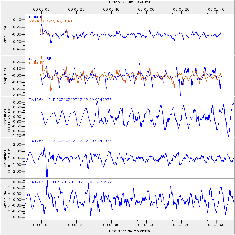
F26K Sheenjek River, AK, USA - Earthquake Result Viewer
*The percent match for this event was below the threshold and hence no stack was calculated.
| Earthquake location: |
Tajikistan-Xinjiang Border Reg. |
| Earthquake latitude/longitude: |
38.1/73.6 |
| Earthquake time(UTC): |
2021/02/12 (043) 17:01:34 GMT |
| Earthquake Depth: |
92 km |
| Earthquake Magnitude: |
5.9 Mww |
| Earthquake Catalog/Contributor: |
NEIC PDE/us |
|
| Network: |
TA USArray Transportable Network (new EarthScope stations) |
| Station: |
F26K Sheenjek River, AK, USA |
| Lat/Lon: |
67.69 N/144.15 W |
| Elevation: |
683 m |
|
| Distance: |
70.7 deg |
| Az: |
14.323 deg |
| Baz: |
329.265 deg |
| Ray Param: |
$rayparam |
*The percent match for this event was below the threshold and hence was not used in the summary stack. |
|
| Radial Match: |
59.36914 % |
| Radial Bump: |
400 |
| Transverse Match: |
49.27986 % |
| Transverse Bump: |
372 |
| SOD ConfigId: |
23341671 |
| Insert Time: |
2021-02-26 18:15:31.803 +0000 |
| GWidth: |
2.5 |
| Max Bumps: |
400 |
| Tol: |
0.001 |
|
Signal To Noise
| Channel | StoN | STA | LTA |
| TA:F26K: :BHZ:20210212T17:12:09.924997Z | 2.437935 | 1.1520731E-6 | 4.7256103E-7 |
| TA:F26K: :BHN:20210212T17:12:09.924997Z | 1.2052033 | 4.2874797E-7 | 3.5574743E-7 |
| TA:F26K: :BHE:20210212T17:12:09.924997Z | 1.6906871 | 5.046797E-7 | 2.9850568E-7 |
| Arrivals |
| Ps | |
| PpPs | |
| PsPs/PpSs | |


