You are here: Home > Network List > GE - GEOFON Stations List
> Station KSDI GII Station Kfar Sold, Israel > Earthquake Result Viewer
KSDI GII Station Kfar Sold, Israel - Earthquake Result Viewer
| Earthquake location: |
Mindoro, Philippines |
| Earthquake latitude/longitude: |
13.9/120.5 |
| Earthquake time(UTC): |
2004/10/08 (282) 14:36:06 GMT |
| Earthquake Depth: |
105 km |
| Earthquake Magnitude: |
6.3 MB, 6.5 MW, 6.4 MW |
| Earthquake Catalog/Contributor: |
WHDF/NEIC |
|
| Network: |
GE GEOFON |
| Station: |
KSDI GII Station Kfar Sold, Israel |
| Lat/Lon: |
33.19 N/35.66 E |
| Elevation: |
123 m |
|
| Distance: |
78.3 deg |
| Az: |
301.468 deg |
| Baz: |
80.995 deg |
| Ray Param: |
0.04950459 |
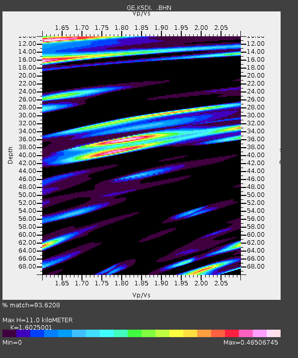
| Estimated Moho Depth: |
11.0 km |
| Estimated Crust Vp/Vs: |
1.60 |
| Assumed Crust Vp: |
5.738 km/s |
| Estimated Crust Vs: |
3.581 km/s |
| Estimated Crust Poisson's Ratio: |
0.18 |
|
| Radial Match: |
93.6208 % |
| Radial Bump: |
400 |
| Transverse Match: |
86.97228 % |
| Transverse Bump: |
400 |
| SOD ConfigId: |
2459 |
| Insert Time: |
2010-03-09 05:26:30.958 +0000 |
| GWidth: |
2.5 |
| Max Bumps: |
400 |
| Tol: |
0.001 |
|

Signal To Noise
| Channel | StoN | STA | LTA |
| GE:KSDI: :BHN:20041008T14:47:23.578018Z | 1.8994573 | 1.7707522E-7 | 9.322411E-8 |
| GE:KSDI: :BHE:20041008T14:47:23.578018Z | 3.0462844 | 3.3979367E-7 | 1.1154365E-7 |
| GE:KSDI: :BHZ:20041008T14:47:23.578018Z | 9.721747 | 9.314193E-7 | 9.5807806E-8 |
| Arrivals |
| Ps | 1.2 SECOND |
| PpPs | 4.9 SECOND |
| PsPs/PpSs | 6.0 SECOND |


