You are here: Home > Network List > XL17 - McGill Dawson-Septimus Induced Seismicity Study () Stations List
> Station MG07 Z > Earthquake Result Viewer
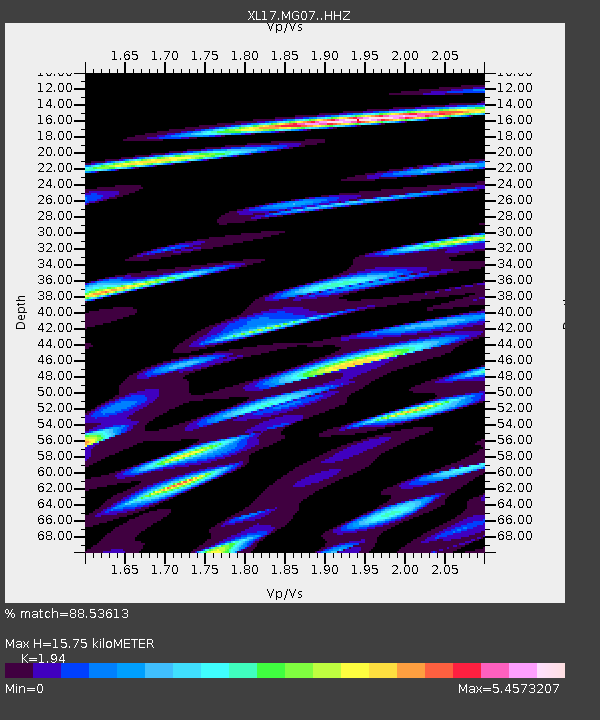
MG07 Z - Earthquake Result Viewer
| Earthquake location: |
Tajikistan-Xinjiang Border Reg. |
| Earthquake latitude/longitude: |
38.1/73.6 |
| Earthquake time(UTC): |
2021/02/12 (043) 17:01:34 GMT |
| Earthquake Depth: |
92 km |
| Earthquake Magnitude: |
5.9 Mww |
| Earthquake Catalog/Contributor: |
NEIC PDE/us |
|
| Network: |
XL McGill Dawson-Septimus Induced Seismicity Study () |
| Station: |
MG07 Z |
| Lat/Lon: |
55.78 N/120.40 W |
| Elevation: |
749 m |
|
| Distance: |
85.7 deg |
| Az: |
7.861 deg |
| Baz: |
348.993 deg |
| Ray Param: |
0.044398177 |
| Estimated Moho Depth: |
15.75 km |
| Estimated Crust Vp/Vs: |
1.94 |
| Assumed Crust Vp: |
6.303 km/s |
| Estimated Crust Vs: |
3.249 km/s |
| Estimated Crust Poisson's Ratio: |
0.32 |
|
| Radial Match: |
88.53613 % |
| Radial Bump: |
202 |
| Transverse Match: |
79.49252 % |
| Transverse Bump: |
243 |
| SOD ConfigId: |
23341671 |
| Insert Time: |
2021-02-26 18:18:36.936 +0000 |
| GWidth: |
2.5 |
| Max Bumps: |
400 |
| Tol: |
0.001 |
|

Signal To Noise
| Channel | StoN | STA | LTA |
| XL:MG07: :HHZ:20210212T17:13:32.180002Z | 2.056265 | 9.8966595E-9 | 4.8129296E-9 |
| XL:MG07: :HHN:20210212T17:13:32.180002Z | 3.6782804 | 1.4985757E-7 | 4.0741202E-8 |
| XL:MG07: :HHE:20210212T17:13:32.180002Z | 1.0568714 | 3.9285912E-9 | 3.7171894E-9 |
| Arrivals |
| Ps | 2.4 SECOND |
| PpPs | 7.2 SECOND |
| PsPs/PpSs | 9.6 SECOND |


