You are here: Home > Network List > GE - GEOFON Stations List
> Station KSDI GII Station Kfar Sold, Israel > Earthquake Result Viewer
KSDI GII Station Kfar Sold, Israel - Earthquake Result Viewer
| Earthquake location: |
Hokkaido, Japan Region |
| Earthquake latitude/longitude: |
42.9/144.8 |
| Earthquake time(UTC): |
2004/04/11 (102) 18:06:12 GMT |
| Earthquake Depth: |
42 km |
| Earthquake Magnitude: |
5.7 MB, 5.7 MS, 6.1 MW, 6.1 MW |
| Earthquake Catalog/Contributor: |
WHDF/NEIC |
|
| Network: |
GE GEOFON |
| Station: |
KSDI GII Station Kfar Sold, Israel |
| Lat/Lon: |
33.19 N/35.66 E |
| Elevation: |
123 m |
|
| Distance: |
80.4 deg |
| Az: |
306.552 deg |
| Baz: |
44.73 deg |
| Ray Param: |
0.04825889 |
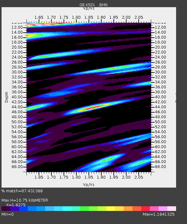
| Estimated Moho Depth: |
10.75 km |
| Estimated Crust Vp/Vs: |
1.63 |
| Assumed Crust Vp: |
5.738 km/s |
| Estimated Crust Vs: |
3.526 km/s |
| Estimated Crust Poisson's Ratio: |
0.20 |
|
| Radial Match: |
87.431366 % |
| Radial Bump: |
400 |
| Transverse Match: |
89.69368 % |
| Transverse Bump: |
400 |
| SOD ConfigId: |
2459 |
| Insert Time: |
2010-03-09 05:26:44.913 +0000 |
| GWidth: |
2.5 |
| Max Bumps: |
400 |
| Tol: |
0.001 |
|

Signal To Noise
| Channel | StoN | STA | LTA |
| GE:KSDI: :BHN:20040411T18:17:48.354023Z | 4.5733337 | 2.4775693E-7 | 5.417425E-8 |
| GE:KSDI: :BHE:20040411T18:17:48.37801Z | 3.8066094 | 2.6887082E-7 | 7.063263E-8 |
| GE:KSDI: :BHZ:20040411T18:17:48.37801Z | 9.132451 | 1.0237973E-6 | 1.12105425E-7 |
| Arrivals |
| Ps | 1.2 SECOND |
| PpPs | 4.8 SECOND |
| PsPs/PpSs | 6.0 SECOND |


