You are here: Home > Network List > GE - GEOFON Stations List
> Station KSDI GII Station Kfar Sold, Israel > Earthquake Result Viewer
KSDI GII Station Kfar Sold, Israel - Earthquake Result Viewer
| Earthquake location: |
Savu Sea |
| Earthquake latitude/longitude: |
-9.4/122.8 |
| Earthquake time(UTC): |
2004/04/23 (114) 01:50:30 GMT |
| Earthquake Depth: |
66 km |
| Earthquake Magnitude: |
6.5 MB, 6.7 MW, 6.7 MW |
| Earthquake Catalog/Contributor: |
WHDF/NEIC |
|
| Network: |
GE GEOFON |
| Station: |
KSDI GII Station Kfar Sold, Israel |
| Lat/Lon: |
33.19 N/35.66 E |
| Elevation: |
123 m |
|
| Distance: |
92.7 deg |
| Az: |
303.024 deg |
| Baz: |
99.332 deg |
| Ray Param: |
0.041372363 |
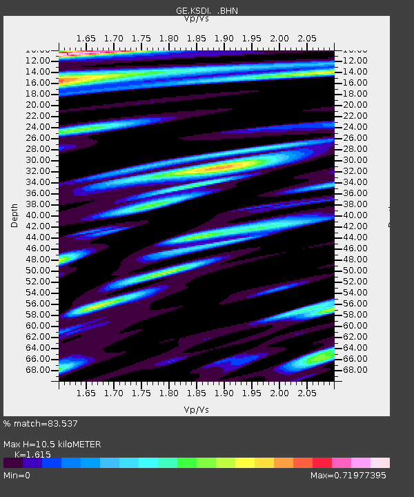
| Estimated Moho Depth: |
10.5 km |
| Estimated Crust Vp/Vs: |
1.62 |
| Assumed Crust Vp: |
5.738 km/s |
| Estimated Crust Vs: |
3.553 km/s |
| Estimated Crust Poisson's Ratio: |
0.19 |
|
| Radial Match: |
83.537 % |
| Radial Bump: |
400 |
| Transverse Match: |
73.15004 % |
| Transverse Bump: |
400 |
| SOD ConfigId: |
2459 |
| Insert Time: |
2010-03-09 05:26:50.334 +0000 |
| GWidth: |
2.5 |
| Max Bumps: |
400 |
| Tol: |
0.001 |
|

Signal To Noise
| Channel | StoN | STA | LTA |
| GE:KSDI: :BHN:20040423T02:03:03.803008Z | 1.0051057 | 1.249749E-7 | 1.2434006E-7 |
| GE:KSDI: :BHE:20040423T02:03:03.829009Z | 2.3169377 | 2.751945E-7 | 1.187751E-7 |
| GE:KSDI: :BHZ:20040423T02:03:03.829009Z | 6.6902843 | 1.0027022E-6 | 1.498744E-7 |
| Arrivals |
| Ps | 1.1 SECOND |
| PpPs | 4.7 SECOND |
| PsPs/PpSs | 5.8 SECOND |


