You are here: Home > Network List > CI - Caltech Regional Seismic Network Stations List
> Station LRL Laurel Mtn Radio Fac, Ridgecrest, CA, USA > Earthquake Result Viewer
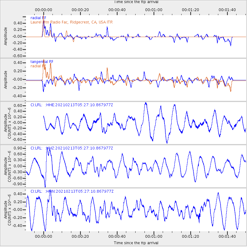
LRL Laurel Mtn Radio Fac, Ridgecrest, CA, USA - Earthquake Result Viewer
*The percent match for this event was below the threshold and hence no stack was calculated.
| Earthquake location: |
Peru-Ecuador Border Region |
| Earthquake latitude/longitude: |
-4.1/-80.2 |
| Earthquake time(UTC): |
2021/02/13 (044) 05:18:33 GMT |
| Earthquake Depth: |
71 km |
| Earthquake Magnitude: |
5.3 Mww |
| Earthquake Catalog/Contributor: |
NEIC PDE/us |
|
| Network: |
CI Caltech Regional Seismic Network |
| Station: |
LRL Laurel Mtn Radio Fac, Ridgecrest, CA, USA |
| Lat/Lon: |
35.48 N/117.68 W |
| Elevation: |
1340 m |
|
| Distance: |
52.8 deg |
| Az: |
321.378 deg |
| Baz: |
130.284 deg |
| Ray Param: |
$rayparam |
*The percent match for this event was below the threshold and hence was not used in the summary stack. |
|
| Radial Match: |
63.26416 % |
| Radial Bump: |
400 |
| Transverse Match: |
55.21914 % |
| Transverse Bump: |
400 |
| SOD ConfigId: |
23341671 |
| Insert Time: |
2021-02-27 06:25:54.708 +0000 |
| GWidth: |
2.5 |
| Max Bumps: |
400 |
| Tol: |
0.001 |
|
Signal To Noise
| Channel | StoN | STA | LTA |
| CI:LRL: :HHZ:20210213T05:27:10.867977Z | 2.746458 | 6.6484887E-7 | 2.4207503E-7 |
| CI:LRL: :HHN:20210213T05:27:10.867977Z | 1.0003606 | 3.123016E-7 | 3.1218906E-7 |
| CI:LRL: :HHE:20210213T05:27:10.867977Z | 1.2871883 | 2.3031E-7 | 1.7892486E-7 |
| Arrivals |
| Ps | |
| PpPs | |
| PsPs/PpSs | |


