You are here: Home > Network List > GE - GEOFON Stations List
> Station KSDI GII Station Kfar Sold, Israel > Earthquake Result Viewer
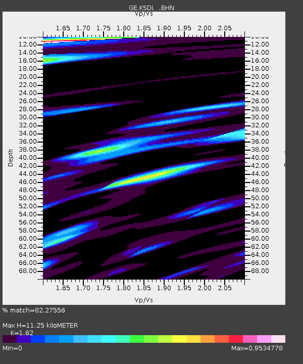
KSDI GII Station Kfar Sold, Israel - Earthquake Result Viewer
| Earthquake location: |
Ryukyu Islands, Japan |
| Earthquake latitude/longitude: |
29.3/130.3 |
| Earthquake time(UTC): |
2005/12/03 (337) 16:10:42 GMT |
| Earthquake Depth: |
48 km |
| Earthquake Magnitude: |
6.0 MB, 5.7 MS, 6.0 MW, 6.0 MW |
| Earthquake Catalog/Contributor: |
WHDF/NEIC |
|
| Network: |
GE GEOFON |
| Station: |
KSDI GII Station Kfar Sold, Israel |
| Lat/Lon: |
33.19 N/35.66 E |
| Elevation: |
123 m |
|
| Distance: |
78.1 deg |
| Az: |
301.318 deg |
| Baz: |
62.821 deg |
| Ray Param: |
0.049813274 |
| Estimated Moho Depth: |
11.25 km |
| Estimated Crust Vp/Vs: |
1.62 |
| Assumed Crust Vp: |
5.738 km/s |
| Estimated Crust Vs: |
3.542 km/s |
| Estimated Crust Poisson's Ratio: |
0.19 |
|
| Radial Match: |
82.27556 % |
| Radial Bump: |
400 |
| Transverse Match: |
84.364426 % |
| Transverse Bump: |
400 |
| SOD ConfigId: |
2422 |
| Insert Time: |
2010-03-09 05:27:01.366 +0000 |
| GWidth: |
2.5 |
| Max Bumps: |
400 |
| Tol: |
0.001 |
|

Signal To Noise
| Channel | StoN | STA | LTA |
| GE:KSDI: :BHN:20051203T16:22:05.056006Z | 4.2114034 | 4.5119896E-7 | 1.0713743E-7 |
| GE:KSDI: :BHE:20051203T16:22:05.056006Z | 9.048792 | 6.947213E-7 | 7.677503E-8 |
| GE:KSDI: :BHZ:20051203T16:22:05.08103Z | 27.84237 | 2.528403E-6 | 9.081135E-8 |
| Arrivals |
| Ps | 1.2 SECOND |
| PpPs | 5.0 SECOND |
| PsPs/PpSs | 6.3 SECOND |


