You are here: Home > Network List > US - United States National Seismic Network Stations List
> Station WMOK Wichita Mountains, Oklahoma, USA > Earthquake Result Viewer
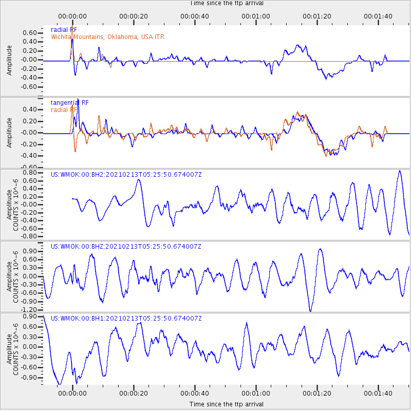
WMOK Wichita Mountains, Oklahoma, USA - Earthquake Result Viewer
*The percent match for this event was below the threshold and hence no stack was calculated.
| Earthquake location: |
Peru-Ecuador Border Region |
| Earthquake latitude/longitude: |
-4.1/-80.2 |
| Earthquake time(UTC): |
2021/02/13 (044) 05:18:33 GMT |
| Earthquake Depth: |
71 km |
| Earthquake Magnitude: |
5.3 Mww |
| Earthquake Catalog/Contributor: |
NEIC PDE/us |
|
| Network: |
US United States National Seismic Network |
| Station: |
WMOK Wichita Mountains, Oklahoma, USA |
| Lat/Lon: |
34.74 N/98.78 W |
| Elevation: |
486 m |
|
| Distance: |
42.4 deg |
| Az: |
337.05 deg |
| Baz: |
151.817 deg |
| Ray Param: |
$rayparam |
*The percent match for this event was below the threshold and hence was not used in the summary stack. |
|
| Radial Match: |
42.12753 % |
| Radial Bump: |
400 |
| Transverse Match: |
51.480152 % |
| Transverse Bump: |
400 |
| SOD ConfigId: |
23341671 |
| Insert Time: |
2021-02-27 06:36:25.032 +0000 |
| GWidth: |
2.5 |
| Max Bumps: |
400 |
| Tol: |
0.001 |
|
Signal To Noise
| Channel | StoN | STA | LTA |
| US:WMOK:00:BHZ:20210213T05:25:50.674007Z | 0.5934062 | 2.5373058E-7 | 4.2758325E-7 |
| US:WMOK:00:BH1:20210213T05:25:50.674007Z | 1.495893 | 8.9041737E-7 | 5.952413E-7 |
| US:WMOK:00:BH2:20210213T05:25:50.674007Z | 1.1606222 | 2.861578E-7 | 2.4655552E-7 |
| Arrivals |
| Ps | |
| PpPs | |
| PsPs/PpSs | |


