You are here: Home > Network List > GE - GEOFON Stations List
> Station KSDI GII Station Kfar Sold, Israel > Earthquake Result Viewer
KSDI GII Station Kfar Sold, Israel - Earthquake Result Viewer
| Earthquake location: |
Banda Sea |
| Earthquake latitude/longitude: |
-6.5/129.9 |
| Earthquake time(UTC): |
2005/03/02 (061) 10:42:12 GMT |
| Earthquake Depth: |
202 km |
| Earthquake Magnitude: |
7.0 MB, 7.1 MW, 7.1 MW |
| Earthquake Catalog/Contributor: |
WHDF/NEIC |
|
| Network: |
GE GEOFON |
| Station: |
KSDI GII Station Kfar Sold, Israel |
| Lat/Lon: |
33.19 N/35.66 E |
| Elevation: |
123 m |
|
| Distance: |
97.1 deg |
| Az: |
302.579 deg |
| Baz: |
93.139 deg |
| Ray Param: |
0.040136382 |
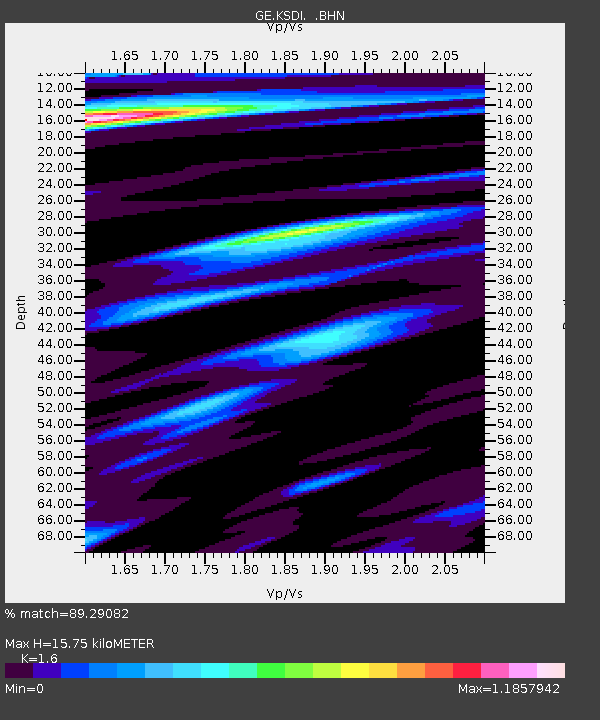
| Estimated Moho Depth: |
15.75 km |
| Estimated Crust Vp/Vs: |
1.60 |
| Assumed Crust Vp: |
5.738 km/s |
| Estimated Crust Vs: |
3.586 km/s |
| Estimated Crust Poisson's Ratio: |
0.18 |
|
| Radial Match: |
89.29082 % |
| Radial Bump: |
400 |
| Transverse Match: |
83.272415 % |
| Transverse Bump: |
400 |
| SOD ConfigId: |
2455 |
| Insert Time: |
2010-03-09 05:27:21.307 +0000 |
| GWidth: |
2.5 |
| Max Bumps: |
400 |
| Tol: |
0.001 |
|

Signal To Noise
| Channel | StoN | STA | LTA |
| GE:KSDI: :BHN:20050302T10:54:49.779011Z | 2.5757966 | 2.5621367E-7 | 9.946967E-8 |
| GE:KSDI: :BHE:20050302T10:54:49.779011Z | 9.336231 | 1.1794083E-6 | 1.2632594E-7 |
| GE:KSDI: :BHZ:20050302T10:54:49.779011Z | 38.620106 | 5.1429424E-6 | 1.3316749E-7 |
| Arrivals |
| Ps | 1.7 SECOND |
| PpPs | 7.0 SECOND |
| PsPs/PpSs | 8.7 SECOND |


