You are here: Home > Network List > GE - GEOFON Stations List
> Station KSDI GII Station Kfar Sold, Israel > Earthquake Result Viewer
KSDI GII Station Kfar Sold, Israel - Earthquake Result Viewer
| Earthquake location: |
Pakistan |
| Earthquake latitude/longitude: |
34.5/73.6 |
| Earthquake time(UTC): |
2005/10/08 (281) 03:50:40 GMT |
| Earthquake Depth: |
26 km |
| Earthquake Magnitude: |
6.9 MB, 7.7 MS, 7.6 MW, 7.3 MW |
| Earthquake Catalog/Contributor: |
WHDF/NEIC |
|
| Network: |
GE GEOFON |
| Station: |
KSDI GII Station Kfar Sold, Israel |
| Lat/Lon: |
33.19 N/35.66 E |
| Elevation: |
123 m |
|
| Distance: |
31.4 deg |
| Az: |
278.444 deg |
| Baz: |
76.86 deg |
| Ray Param: |
0.079057395 |
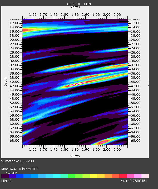
| Estimated Moho Depth: |
41.0 km |
| Estimated Crust Vp/Vs: |
1.85 |
| Assumed Crust Vp: |
5.738 km/s |
| Estimated Crust Vs: |
3.102 km/s |
| Estimated Crust Poisson's Ratio: |
0.29 |
|
| Radial Match: |
90.59208 % |
| Radial Bump: |
400 |
| Transverse Match: |
79.01786 % |
| Transverse Bump: |
400 |
| SOD ConfigId: |
2475 |
| Insert Time: |
2010-03-09 05:27:29.621 +0000 |
| GWidth: |
2.5 |
| Max Bumps: |
400 |
| Tol: |
0.001 |
|

Signal To Noise
| Channel | StoN | STA | LTA |
| GE:KSDI: :BHN:20051008T03:56:29.155011Z | 9.115574 | 8.4803105E-7 | 9.3031005E-8 |
| GE:KSDI: :BHE:20051008T03:56:29.155011Z | 15.059781 | 4.2650286E-6 | 2.8320656E-7 |
| GE:KSDI: :BHZ:20051008T03:56:29.129987Z | 19.316145 | 6.6516996E-6 | 3.443596E-7 |
| Arrivals |
| Ps | 6.4 SECOND |
| PpPs | 19 SECOND |
| PsPs/PpSs | 26 SECOND |


