You are here: Home > Network List > GE - GEOFON Stations List
> Station KSDI GII Station Kfar Sold, Israel > Earthquake Result Viewer
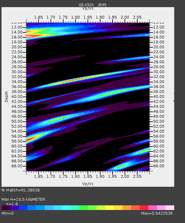
KSDI GII Station Kfar Sold, Israel - Earthquake Result Viewer
| Earthquake location: |
Pakistan |
| Earthquake latitude/longitude: |
34.7/73.1 |
| Earthquake time(UTC): |
2005/10/08 (281) 10:46:28 GMT |
| Earthquake Depth: |
8.0 km |
| Earthquake Magnitude: |
6.0 MB, 6.3 MS, 6.4 MW, 6.2 MW |
| Earthquake Catalog/Contributor: |
WHDF/NEIC |
|
| Network: |
GE GEOFON |
| Station: |
KSDI GII Station Kfar Sold, Israel |
| Lat/Lon: |
33.19 N/35.66 E |
| Elevation: |
123 m |
|
| Distance: |
31.0 deg |
| Az: |
277.946 deg |
| Baz: |
76.601 deg |
| Ray Param: |
0.07919255 |
| Estimated Moho Depth: |
15.5 km |
| Estimated Crust Vp/Vs: |
1.60 |
| Assumed Crust Vp: |
5.738 km/s |
| Estimated Crust Vs: |
3.586 km/s |
| Estimated Crust Poisson's Ratio: |
0.18 |
|
| Radial Match: |
81.36836 % |
| Radial Bump: |
358 |
| Transverse Match: |
73.64086 % |
| Transverse Bump: |
400 |
| SOD ConfigId: |
2475 |
| Insert Time: |
2010-03-09 05:27:30.960 +0000 |
| GWidth: |
2.5 |
| Max Bumps: |
400 |
| Tol: |
0.001 |
|

Signal To Noise
| Channel | StoN | STA | LTA |
| GE:KSDI: :BHN:20051008T10:52:15.805015Z | 1.1674696 | 1.0447092E-7 | 8.9484914E-8 |
| GE:KSDI: :BHE:20051008T10:52:15.805015Z | 2.9756017 | 6.047908E-7 | 2.0324991E-7 |
| GE:KSDI: :BHZ:20051008T10:52:15.77999Z | 14.922027 | 1.6428068E-6 | 1.1009274E-7 |
| Arrivals |
| Ps | 1.7 SECOND |
| PpPs | 6.6 SECOND |
| PsPs/PpSs | 8.3 SECOND |


