You are here: Home > Network List > IW - Intermountain West Stations List
> Station IMW Indian Meadow, Wyoming, USA > Earthquake Result Viewer
IMW Indian Meadow, Wyoming, USA - Earthquake Result Viewer
| Earthquake location: |
Northern Chile |
| Earthquake latitude/longitude: |
-18.5/-69.6 |
| Earthquake time(UTC): |
2017/10/10 (283) 06:32:20 GMT |
| Earthquake Depth: |
82 km |
| Earthquake Magnitude: |
6.3 Mww |
| Earthquake Catalog/Contributor: |
NEIC PDE/us |
|
| Network: |
IW Intermountain West |
| Station: |
IMW Indian Meadow, Wyoming, USA |
| Lat/Lon: |
43.90 N/110.94 W |
| Elevation: |
2646 m |
|
| Distance: |
72.7 deg |
| Az: |
330.021 deg |
| Baz: |
139.016 deg |
| Ray Param: |
0.053292684 |
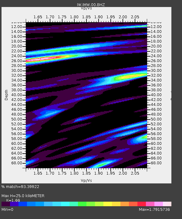
| Estimated Moho Depth: |
25.0 km |
| Estimated Crust Vp/Vs: |
1.66 |
| Assumed Crust Vp: |
6.207 km/s |
| Estimated Crust Vs: |
3.739 km/s |
| Estimated Crust Poisson's Ratio: |
0.22 |
|
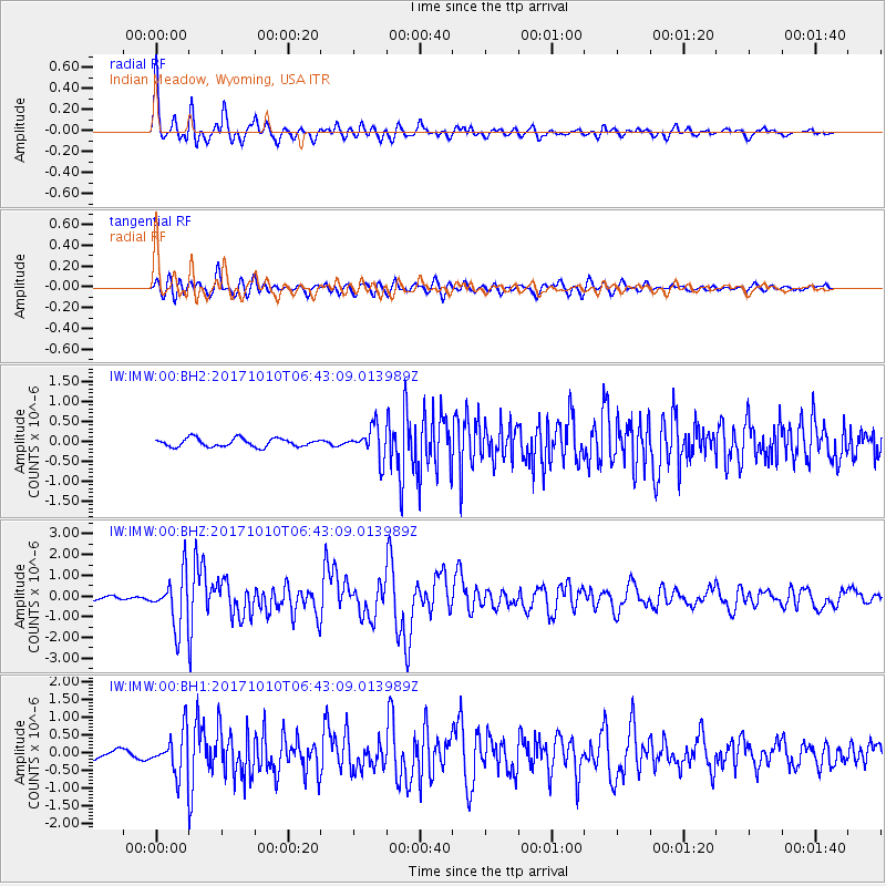
| Radial Match: |
93.39922 % |
| Radial Bump: |
400 |
| Transverse Match: |
87.209526 % |
| Transverse Bump: |
400 |
| SOD ConfigId: |
2364251 |
| Insert Time: |
2017-10-24 06:35:48.815 +0000 |
| GWidth: |
2.5 |
| Max Bumps: |
400 |
| Tol: |
0.001 |
|
Signal To Noise
| Channel | StoN | STA | LTA |
| IW:IMW:00:BHZ:20171010T06:43:09.013989Z | 13.66848 | 1.2409587E-6 | 9.0789804E-8 |
| IW:IMW:00:BH1:20171010T06:43:09.013989Z | 3.8817136 | 5.8913764E-7 | 1.5177257E-7 |
| IW:IMW:00:BH2:20171010T06:43:09.013989Z | 3.7388513 | 3.916717E-7 | 1.04757234E-7 |
| Arrivals |
| Ps | 2.8 SECOND |
| PpPs | 10 SECOND |
| PsPs/PpSs | 13 SECOND |


