You are here: Home > Network List > GE - GEOFON Stations List
> Station BGIO GII/GEOFON Station Bar Giyyora, Israel > Earthquake Result Viewer
BGIO GII/GEOFON Station Bar Giyyora, Israel - Earthquake Result Viewer
| Earthquake location: |
Mindoro, Philippines |
| Earthquake latitude/longitude: |
13.5/121.1 |
| Earthquake time(UTC): |
1994/11/14 (318) 19:15:30 GMT |
| Earthquake Depth: |
33 km |
| Earthquake Magnitude: |
6.1 MB, 7.1 MS, 7.1 UNKNOWN, 7.1 MW |
| Earthquake Catalog/Contributor: |
WHDF/NEIC |
|
| Network: |
GE GEOFON |
| Station: |
BGIO GII/GEOFON Station Bar Giyyora, Israel |
| Lat/Lon: |
31.72 N/35.09 E |
| Elevation: |
752 m |
|
| Distance: |
79.7 deg |
| Az: |
300.215 deg |
| Baz: |
80.484 deg |
| Ray Param: |
0.048763152 |
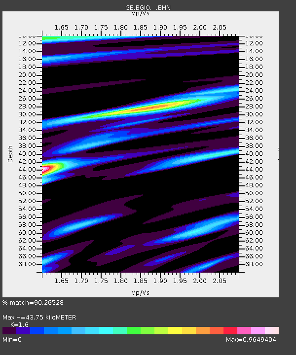
| Estimated Moho Depth: |
43.75 km |
| Estimated Crust Vp/Vs: |
1.60 |
| Assumed Crust Vp: |
6.391 km/s |
| Estimated Crust Vs: |
3.994 km/s |
| Estimated Crust Poisson's Ratio: |
0.18 |
|
| Radial Match: |
90.26528 % |
| Radial Bump: |
400 |
| Transverse Match: |
85.05829 % |
| Transverse Bump: |
400 |
| SOD ConfigId: |
16938 |
| Insert Time: |
2010-03-09 05:27:48.138 +0000 |
| GWidth: |
2.5 |
| Max Bumps: |
400 |
| Tol: |
0.001 |
|

Signal To Noise
| Channel | StoN | STA | LTA |
| GE:BGIO: :BHN:19941114T19:27:03.803027Z | 1.0271434 | 1.8185834E-7 | 1.7705253E-7 |
| GE:BGIO: :BHE:19941114T19:27:03.798022Z | 1.2593622 | 1.8191388E-7 | 1.444492E-7 |
| GE:BGIO: :BHZ:19941114T19:27:03.801013Z | 2.5728452 | 4.918298E-7 | 1.9116182E-7 |
| Arrivals |
| Ps | 4.2 SECOND |
| PpPs | 17 SECOND |
| PsPs/PpSs | 21 SECOND |


