You are here: Home > Network List > GE - GEOFON Stations List
> Station BGIO GII/GEOFON Station Bar Giyyora, Israel > Earthquake Result Viewer
BGIO GII/GEOFON Station Bar Giyyora, Israel - Earthquake Result Viewer
| Earthquake location: |
East Of Kuril Islands |
| Earthquake latitude/longitude: |
44.7/150.2 |
| Earthquake time(UTC): |
1994/08/18 (230) 04:42:59 GMT |
| Earthquake Depth: |
33 km |
| Earthquake Magnitude: |
6.1 MB, 6.5 MS, 6.6 UNKNOWN, 6.5 MW |
| Earthquake Catalog/Contributor: |
WHDF/NEIC |
|
| Network: |
GE GEOFON |
| Station: |
BGIO GII/GEOFON Station Bar Giyyora, Israel |
| Lat/Lon: |
31.72 N/35.09 E |
| Elevation: |
752 m |
|
| Distance: |
83.8 deg |
| Az: |
309.066 deg |
| Baz: |
40.545 deg |
| Ray Param: |
0.04592068 |
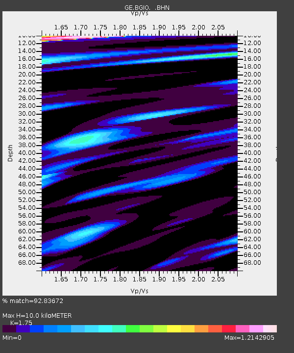
| Estimated Moho Depth: |
10.0 km |
| Estimated Crust Vp/Vs: |
1.75 |
| Assumed Crust Vp: |
6.391 km/s |
| Estimated Crust Vs: |
3.652 km/s |
| Estimated Crust Poisson's Ratio: |
0.26 |
|
| Radial Match: |
92.83672 % |
| Radial Bump: |
400 |
| Transverse Match: |
91.99449 % |
| Transverse Bump: |
400 |
| SOD ConfigId: |
17000 |
| Insert Time: |
2010-03-09 05:27:54.602 +0000 |
| GWidth: |
2.5 |
| Max Bumps: |
400 |
| Tol: |
0.001 |
|

Signal To Noise
| Channel | StoN | STA | LTA |
| GE:BGIO: :BHN:19940818T04:54:54.201013Z | 1.6186559 | 4.4099792E-7 | 2.7244698E-7 |
| GE:BGIO: :BHE:19940818T04:54:54.201013Z | 2.511468 | 5.422044E-7 | 2.1589142E-7 |
| GE:BGIO: :BHZ:19940818T04:54:54.201013Z | 10.111952 | 2.5873433E-6 | 2.5586982E-7 |
| Arrivals |
| Ps | 1.2 SECOND |
| PpPs | 4.2 SECOND |
| PsPs/PpSs | 5.4 SECOND |


