You are here: Home > Network List > GE - GEOFON Stations List
> Station BGIO GII/GEOFON Station Bar Giyyora, Israel > Earthquake Result Viewer
BGIO GII/GEOFON Station Bar Giyyora, Israel - Earthquake Result Viewer
| Earthquake location: |
Kuril Islands |
| Earthquake latitude/longitude: |
44.6/149.4 |
| Earthquake time(UTC): |
1995/12/03 (337) 18:01:08 GMT |
| Earthquake Depth: |
33 km |
| Earthquake Magnitude: |
6.6 MB, 8.0 MS |
| Earthquake Catalog/Contributor: |
WHDF/NEIC |
|
| Network: |
GE GEOFON |
| Station: |
BGIO GII/GEOFON Station Bar Giyyora, Israel |
| Lat/Lon: |
31.72 N/35.09 E |
| Elevation: |
752 m |
|
| Distance: |
83.4 deg |
| Az: |
308.557 deg |
| Baz: |
40.987 deg |
| Ray Param: |
0.046190053 |
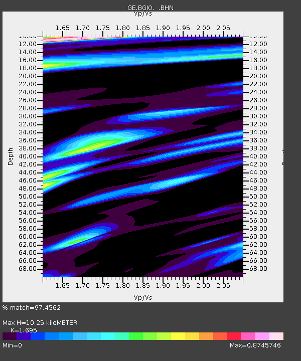
| Estimated Moho Depth: |
10.25 km |
| Estimated Crust Vp/Vs: |
1.70 |
| Assumed Crust Vp: |
6.391 km/s |
| Estimated Crust Vs: |
3.77 km/s |
| Estimated Crust Poisson's Ratio: |
0.23 |
|
| Radial Match: |
97.4562 % |
| Radial Bump: |
400 |
| Transverse Match: |
95.61842 % |
| Transverse Bump: |
400 |
| SOD ConfigId: |
6273 |
| Insert Time: |
2010-03-09 05:28:08.788 +0000 |
| GWidth: |
2.5 |
| Max Bumps: |
400 |
| Tol: |
0.001 |
|

Signal To Noise
| Channel | StoN | STA | LTA |
| GE:BGIO: :BHN:19951203T18:13:01.151001Z | 1.8624958 | 3.2065267E-7 | 1.721629E-7 |
| GE:BGIO: :BHE:19951203T18:13:01.151001Z | 1.7545521 | 1.9982606E-7 | 1.1389007E-7 |
| GE:BGIO: :BHZ:19951203T18:13:01.151001Z | 4.824441 | 1.0134852E-6 | 2.100731E-7 |
| Arrivals |
| Ps | 1.1 SECOND |
| PpPs | 4.2 SECOND |
| PsPs/PpSs | 5.4 SECOND |


