You are here: Home > Network List > AV - Alaska Volcano Observatory Stations List
> Station KAB2 Katmai Barrier Ridge Two, Alaska > Earthquake Result Viewer
KAB2 Katmai Barrier Ridge Two, Alaska - Earthquake Result Viewer
| Earthquake location: |
Near East Coast Of Honshu, Japan |
| Earthquake latitude/longitude: |
37.7/142.0 |
| Earthquake time(UTC): |
2021/02/13 (044) 14:07:49 GMT |
| Earthquake Depth: |
54 km |
| Earthquake Magnitude: |
7.0 mww |
| Earthquake Catalog/Contributor: |
NEIC PDE/us |
|
| Network: |
AV Alaska Volcano Observatory |
| Station: |
KAB2 Katmai Barrier Ridge Two, Alaska |
| Lat/Lon: |
58.13 N/154.98 W |
| Elevation: |
908 m |
|
| Distance: |
45.0 deg |
| Az: |
41.952 deg |
| Baz: |
271.457 deg |
| Ray Param: |
0.071409136 |
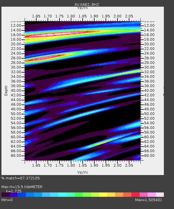
| Estimated Moho Depth: |
15.5 km |
| Estimated Crust Vp/Vs: |
1.73 |
| Assumed Crust Vp: |
6.438 km/s |
| Estimated Crust Vs: |
3.732 km/s |
| Estimated Crust Poisson's Ratio: |
0.25 |
|
| Radial Match: |
87.372185 % |
| Radial Bump: |
400 |
| Transverse Match: |
70.180405 % |
| Transverse Bump: |
400 |
| SOD ConfigId: |
23341671 |
| Insert Time: |
2021-02-27 15:13:29.924 +0000 |
| GWidth: |
2.5 |
| Max Bumps: |
400 |
| Tol: |
0.001 |
|

Signal To Noise
| Channel | StoN | STA | LTA |
| AV:KAB2: :BHZ:20210213T14:15:29.39899Z | 2.720863 | 3.0511055E-6 | 1.1213742E-6 |
| AV:KAB2: :BHN:20210213T14:15:29.39899Z | 1.9647909 | 1.6905408E-6 | 8.6041763E-7 |
| AV:KAB2: :BHE:20210213T14:15:29.39899Z | 1.390226 | 1.4113007E-6 | 1.0151591E-6 |
| Arrivals |
| Ps | 1.9 SECOND |
| PpPs | 6.1 SECOND |
| PsPs/PpSs | 8.0 SECOND |


