You are here: Home > Network List > C0 - Colorado Geological Survey Seismic Network Stations List
> Station LAMA Lamar Colorado > Earthquake Result Viewer
LAMA Lamar Colorado - Earthquake Result Viewer
| Earthquake location: |
Near East Coast Of Honshu, Japan |
| Earthquake latitude/longitude: |
37.7/142.0 |
| Earthquake time(UTC): |
2021/02/13 (044) 14:07:49 GMT |
| Earthquake Depth: |
54 km |
| Earthquake Magnitude: |
7.0 mww |
| Earthquake Catalog/Contributor: |
NEIC PDE/us |
|
| Network: |
C0 Colorado Geological Survey Seismic Network |
| Station: |
LAMA Lamar Colorado |
| Lat/Lon: |
38.27 N/102.65 W |
| Elevation: |
1182 m |
|
| Distance: |
83.8 deg |
| Az: |
45.677 deg |
| Baz: |
313.854 deg |
| Ray Param: |
0.04583553 |
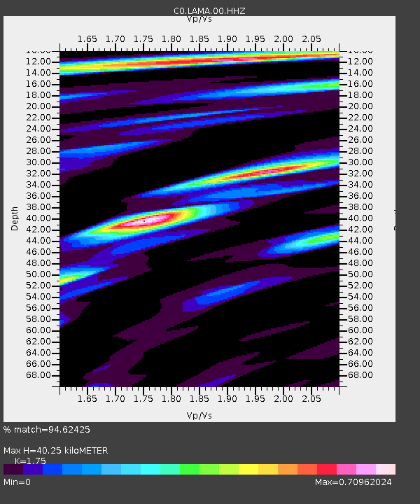
| Estimated Moho Depth: |
40.25 km |
| Estimated Crust Vp/Vs: |
1.75 |
| Assumed Crust Vp: |
6.242 km/s |
| Estimated Crust Vs: |
3.567 km/s |
| Estimated Crust Poisson's Ratio: |
0.26 |
|
| Radial Match: |
94.62425 % |
| Radial Bump: |
331 |
| Transverse Match: |
87.929085 % |
| Transverse Bump: |
400 |
| SOD ConfigId: |
23341671 |
| Insert Time: |
2021-02-27 15:14:15.093 +0000 |
| GWidth: |
2.5 |
| Max Bumps: |
400 |
| Tol: |
0.001 |
|

Signal To Noise
| Channel | StoN | STA | LTA |
| C0:LAMA:00:HHZ:20210213T14:19:42.059024Z | 2.1221988 | 5.13032E-7 | 2.417455E-7 |
| C0:LAMA:00:HHN:20210213T14:19:42.059024Z | 0.38285926 | 1.2057183E-7 | 3.1492468E-7 |
| C0:LAMA:00:HHE:20210213T14:19:42.059024Z | 1.4571933 | 3.3426477E-7 | 2.2938944E-7 |
| Arrivals |
| Ps | 5.0 SECOND |
| PpPs | 17 SECOND |
| PsPs/PpSs | 22 SECOND |


