You are here: Home > Network List > GE - GEOFON Stations List
> Station BGIO GII/GEOFON Station Bar Giyyora, Israel > Earthquake Result Viewer
BGIO GII/GEOFON Station Bar Giyyora, Israel - Earthquake Result Viewer
| Earthquake location: |
Samar, Philippines |
| Earthquake latitude/longitude: |
12.0/125.7 |
| Earthquake time(UTC): |
1995/04/21 (111) 00:09:56 GMT |
| Earthquake Depth: |
33 km |
| Earthquake Magnitude: |
6.1 MB, 6.9 MS, 6.9 UNKNOWN, 6.8 MW |
| Earthquake Catalog/Contributor: |
WHDF/NEIC |
|
| Network: |
GE GEOFON |
| Station: |
BGIO GII/GEOFON Station Bar Giyyora, Israel |
| Lat/Lon: |
31.72 N/35.09 E |
| Elevation: |
752 m |
|
| Distance: |
84.3 deg |
| Az: |
301.09 deg |
| Baz: |
79.491 deg |
| Ray Param: |
0.04553282 |
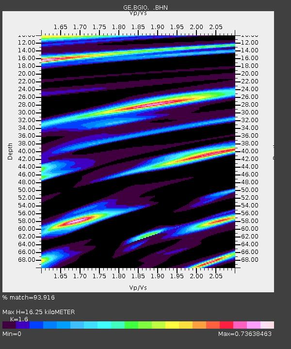
| Estimated Moho Depth: |
16.25 km |
| Estimated Crust Vp/Vs: |
1.60 |
| Assumed Crust Vp: |
6.391 km/s |
| Estimated Crust Vs: |
3.994 km/s |
| Estimated Crust Poisson's Ratio: |
0.18 |
|
| Radial Match: |
93.916 % |
| Radial Bump: |
400 |
| Transverse Match: |
90.68616 % |
| Transverse Bump: |
400 |
| SOD ConfigId: |
6273 |
| Insert Time: |
2010-03-09 05:28:22.747 +0000 |
| GWidth: |
2.5 |
| Max Bumps: |
400 |
| Tol: |
0.001 |
|

Signal To Noise
| Channel | StoN | STA | LTA |
| GE:BGIO: :BHN:19950421T00:21:53.592029Z | 1.2453941 | 1.329626E-7 | 1.0676346E-7 |
| GE:BGIO: :BHE:19950421T00:21:53.592029Z | 7.8341064 | 6.555505E-7 | 8.367903E-8 |
| GE:BGIO: :BHZ:19950421T00:21:53.592029Z | 22.83293 | 2.4752567E-6 | 1.0840733E-7 |
| Arrivals |
| Ps | 1.6 SECOND |
| PpPs | 6.4 SECOND |
| PsPs/PpSs | 8.0 SECOND |


