You are here: Home > Network List > CN - Canadian National Seismograph Network Stations List
> Station CBB Campbell River, BC, CA > Earthquake Result Viewer
CBB Campbell River, BC, CA - Earthquake Result Viewer
| Earthquake location: |
Near East Coast Of Honshu, Japan |
| Earthquake latitude/longitude: |
37.7/142.0 |
| Earthquake time(UTC): |
2021/02/13 (044) 14:07:49 GMT |
| Earthquake Depth: |
54 km |
| Earthquake Magnitude: |
7.0 mww |
| Earthquake Catalog/Contributor: |
NEIC PDE/us |
|
| Network: |
CN Canadian National Seismograph Network |
| Station: |
CBB Campbell River, BC, CA |
| Lat/Lon: |
50.03 N/125.37 W |
| Elevation: |
277 m |
|
| Distance: |
63.8 deg |
| Az: |
45.893 deg |
| Baz: |
297.952 deg |
| Ray Param: |
0.05922982 |
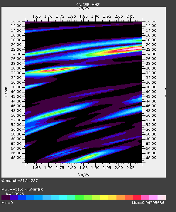
| Estimated Moho Depth: |
21.0 km |
| Estimated Crust Vp/Vs: |
2.10 |
| Assumed Crust Vp: |
6.566 km/s |
| Estimated Crust Vs: |
3.13 km/s |
| Estimated Crust Poisson's Ratio: |
0.35 |
|
| Radial Match: |
81.14237 % |
| Radial Bump: |
400 |
| Transverse Match: |
76.50441 % |
| Transverse Bump: |
400 |
| SOD ConfigId: |
23341671 |
| Insert Time: |
2021-02-27 15:16:43.385 +0000 |
| GWidth: |
2.5 |
| Max Bumps: |
400 |
| Tol: |
0.001 |
|

Signal To Noise
| Channel | StoN | STA | LTA |
| CN:CBB: :HHZ:20210213T14:17:45.390018Z | 2.5193143 | 2.5715542E-6 | 1.0207358E-6 |
| CN:CBB: :HHN:20210213T14:17:45.390018Z | 1.9400231 | 1.1507781E-6 | 5.931775E-7 |
| CN:CBB: :HHE:20210213T14:17:45.390018Z | 1.4894041 | 1.9505933E-6 | 1.3096468E-6 |
| Arrivals |
| Ps | 3.6 SECOND |
| PpPs | 9.5 SECOND |
| PsPs/PpSs | 13 SECOND |


