You are here: Home > Network List > GO - National Seismic Network of Georgia Stations List
> Station BATM Batumi > Earthquake Result Viewer
BATM Batumi - Earthquake Result Viewer
| Earthquake location: |
Near East Coast Of Honshu, Japan |
| Earthquake latitude/longitude: |
37.7/142.0 |
| Earthquake time(UTC): |
2021/02/13 (044) 14:07:49 GMT |
| Earthquake Depth: |
54 km |
| Earthquake Magnitude: |
7.0 mww |
| Earthquake Catalog/Contributor: |
NEIC PDE/us |
|
| Network: |
GO National Seismic Network of Georgia |
| Station: |
BATM Batumi |
| Lat/Lon: |
41.60 N/41.69 E |
| Elevation: |
298 m |
|
| Distance: |
72.8 deg |
| Az: |
309.414 deg |
| Baz: |
54.813 deg |
| Ray Param: |
0.053350497 |
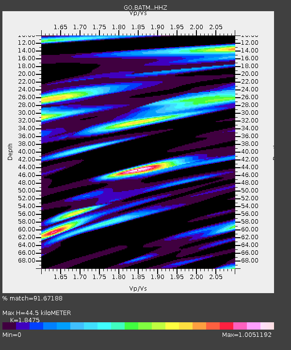
| Estimated Moho Depth: |
44.5 km |
| Estimated Crust Vp/Vs: |
1.85 |
| Assumed Crust Vp: |
6.401 km/s |
| Estimated Crust Vs: |
3.465 km/s |
| Estimated Crust Poisson's Ratio: |
0.29 |
|
| Radial Match: |
91.67188 % |
| Radial Bump: |
400 |
| Transverse Match: |
84.84854 % |
| Transverse Bump: |
400 |
| SOD ConfigId: |
23341671 |
| Insert Time: |
2021-02-27 15:19:29.569 +0000 |
| GWidth: |
2.5 |
| Max Bumps: |
400 |
| Tol: |
0.001 |
|

Signal To Noise
| Channel | StoN | STA | LTA |
| GO:BATM: :HHZ:20210213T14:18:41.359988Z | 6.890658 | 2.4266574E-6 | 3.5216627E-7 |
| GO:BATM: :HHN:20210213T14:18:41.359988Z | 2.8840053 | 9.619712E-7 | 3.3355388E-7 |
| GO:BATM: :HHE:20210213T14:18:41.359988Z | 1.9915813 | 6.71179E-7 | 3.370081E-7 |
| Arrivals |
| Ps | 6.1 SECOND |
| PpPs | 19 SECOND |
| PsPs/PpSs | 25 SECOND |


