You are here: Home > Network List > GS - US Geological Survey Networks Stations List
> Station OK051 E0350 and S34600 Roads, Ralston, OK > Earthquake Result Viewer
OK051 E0350 and S34600 Roads, Ralston, OK - Earthquake Result Viewer
| Earthquake location: |
Near East Coast Of Honshu, Japan |
| Earthquake latitude/longitude: |
37.7/142.0 |
| Earthquake time(UTC): |
2021/02/13 (044) 14:07:49 GMT |
| Earthquake Depth: |
54 km |
| Earthquake Magnitude: |
7.0 mww |
| Earthquake Catalog/Contributor: |
NEIC PDE/us |
|
| Network: |
GS US Geological Survey Networks |
| Station: |
OK051 E0350 and S34600 Roads, Ralston, OK |
| Lat/Lon: |
36.51 N/96.84 W |
| Elevation: |
263 m |
|
| Distance: |
88.3 deg |
| Az: |
43.605 deg |
| Baz: |
317.226 deg |
| Ray Param: |
0.042599235 |
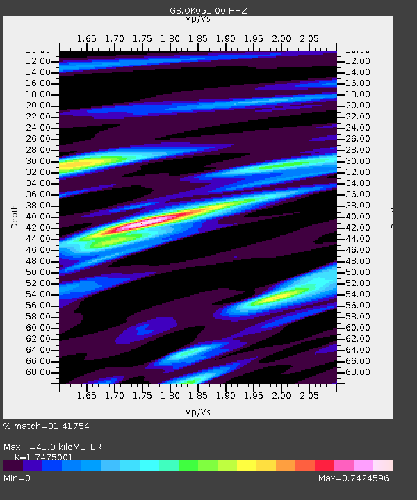
| Estimated Moho Depth: |
41.0 km |
| Estimated Crust Vp/Vs: |
1.75 |
| Assumed Crust Vp: |
6.483 km/s |
| Estimated Crust Vs: |
3.71 km/s |
| Estimated Crust Poisson's Ratio: |
0.26 |
|
| Radial Match: |
81.41754 % |
| Radial Bump: |
400 |
| Transverse Match: |
50.960583 % |
| Transverse Bump: |
400 |
| SOD ConfigId: |
23341671 |
| Insert Time: |
2021-02-27 15:19:45.389 +0000 |
| GWidth: |
2.5 |
| Max Bumps: |
400 |
| Tol: |
0.001 |
|
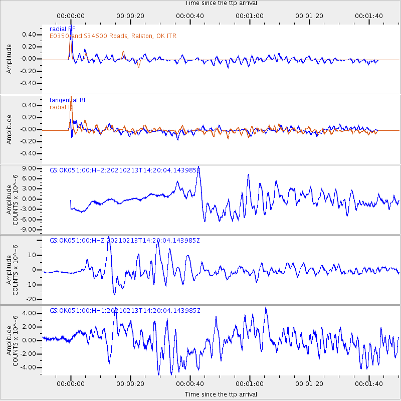
Signal To Noise
| Channel | StoN | STA | LTA |
| GS:OK051:00:HHZ:20210213T14:20:04.143985Z | 0.7801067 | 2.2574511E-6 | 2.893772E-6 |
| GS:OK051:00:HH1:20210213T14:20:04.143985Z | 0.7885921 | 2.9564842E-6 | 3.7490665E-6 |
| GS:OK051:00:HH2:20210213T14:20:04.143985Z | 1.9846276 | 2.4382002E-6 | 1.2285429E-6 |
| Arrivals |
| Ps | 4.8 SECOND |
| PpPs | 17 SECOND |
| PsPs/PpSs | 22 SECOND |


