You are here: Home > Network List > II - Global Seismograph Network (GSN - IRIS/IDA) Stations List
> Station COCO West Island, Cocos (Keeling) Islands > Earthquake Result Viewer
COCO West Island, Cocos (Keeling) Islands - Earthquake Result Viewer
| Earthquake location: |
Near East Coast Of Honshu, Japan |
| Earthquake latitude/longitude: |
37.7/142.0 |
| Earthquake time(UTC): |
2021/02/13 (044) 14:07:49 GMT |
| Earthquake Depth: |
54 km |
| Earthquake Magnitude: |
7.0 mww |
| Earthquake Catalog/Contributor: |
NEIC PDE/us |
|
| Network: |
II Global Seismograph Network (GSN - IRIS/IDA) |
| Station: |
COCO West Island, Cocos (Keeling) Islands |
| Lat/Lon: |
12.19 S/96.83 E |
| Elevation: |
1.0 m |
|
| Distance: |
65.2 deg |
| Az: |
229.785 deg |
| Baz: |
38.288 deg |
| Ray Param: |
0.058303338 |
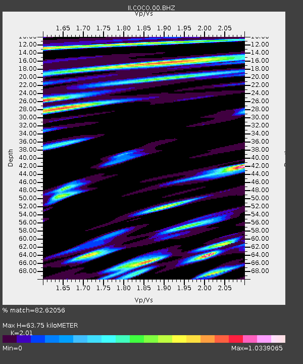
| Estimated Moho Depth: |
63.75 km |
| Estimated Crust Vp/Vs: |
2.01 |
| Assumed Crust Vp: |
4.24 km/s |
| Estimated Crust Vs: |
2.109 km/s |
| Estimated Crust Poisson's Ratio: |
0.34 |
|
| Radial Match: |
82.62056 % |
| Radial Bump: |
400 |
| Transverse Match: |
72.0668 % |
| Transverse Bump: |
400 |
| SOD ConfigId: |
23341671 |
| Insert Time: |
2021-02-27 15:20:20.747 +0000 |
| GWidth: |
2.5 |
| Max Bumps: |
400 |
| Tol: |
0.001 |
|
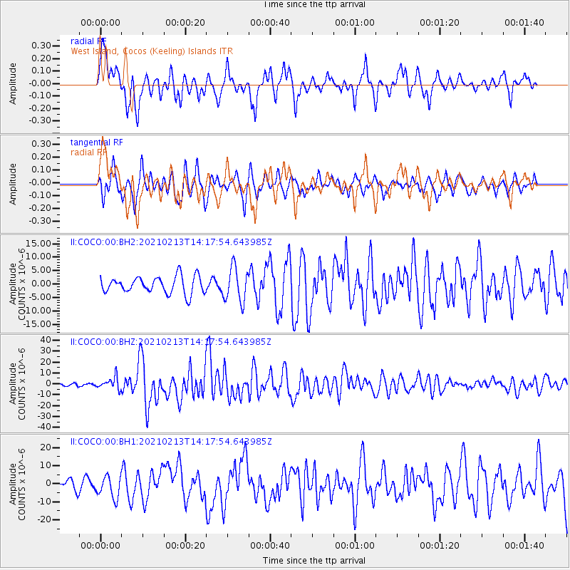
Signal To Noise
| Channel | StoN | STA | LTA |
| II:COCO:00:BHZ:20210213T14:17:54.643985Z | 4.015166 | 5.560538E-6 | 1.3848838E-6 |
| II:COCO:00:BH1:20210213T14:17:54.643985Z | 2.4912019 | 6.079991E-6 | 2.4405856E-6 |
| II:COCO:00:BH2:20210213T14:17:54.643985Z | 2.0855105 | 6.4781175E-6 | 3.1062502E-6 |
| Arrivals |
| Ps | 15 SECOND |
| PpPs | 45 SECOND |
| PsPs/PpSs | 60 SECOND |


