You are here: Home > Network List > GE - GEOFON Stations List
> Station BGIO GII/GEOFON Station Bar Giyyora, Israel > Earthquake Result Viewer
BGIO GII/GEOFON Station Bar Giyyora, Israel - Earthquake Result Viewer
| Earthquake location: |
East Of Kuril Islands |
| Earthquake latitude/longitude: |
43.4/148.0 |
| Earthquake time(UTC): |
1996/03/09 (069) 16:15:36 GMT |
| Earthquake Depth: |
33 km |
| Earthquake Magnitude: |
5.6 MB, 5.9 MS, 6.1 UNKNOWN, 5.5 MS |
| Earthquake Catalog/Contributor: |
WHDF/NEIC |
|
| Network: |
GE GEOFON |
| Station: |
BGIO GII/GEOFON Station Bar Giyyora, Israel |
| Lat/Lon: |
31.72 N/35.09 E |
| Elevation: |
752 m |
|
| Distance: |
83.3 deg |
| Az: |
307.788 deg |
| Baz: |
42.505 deg |
| Ray Param: |
0.046239085 |
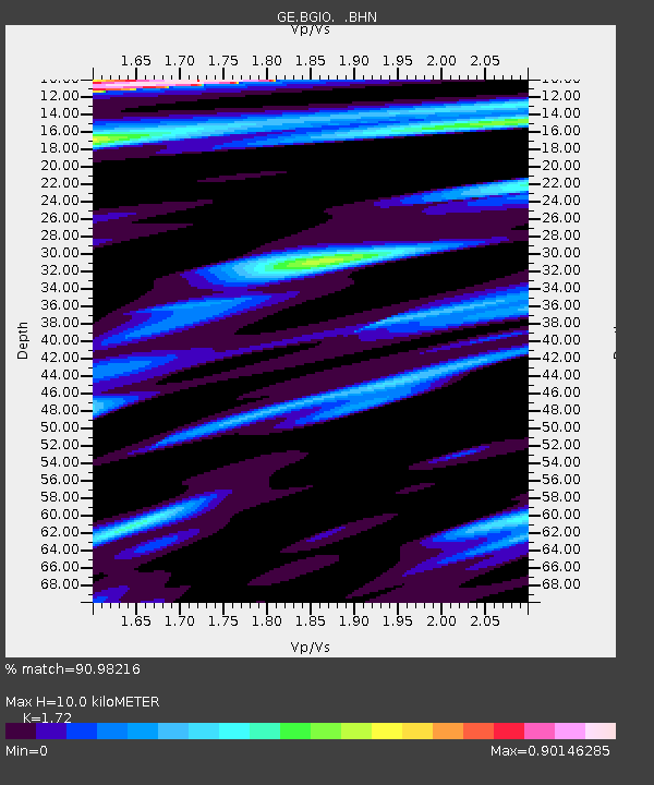
| Estimated Moho Depth: |
10.0 km |
| Estimated Crust Vp/Vs: |
1.72 |
| Assumed Crust Vp: |
6.391 km/s |
| Estimated Crust Vs: |
3.715 km/s |
| Estimated Crust Poisson's Ratio: |
0.24 |
|
| Radial Match: |
90.98216 % |
| Radial Bump: |
400 |
| Transverse Match: |
75.97208 % |
| Transverse Bump: |
400 |
| SOD ConfigId: |
6273 |
| Insert Time: |
2010-03-09 05:28:55.193 +0000 |
| GWidth: |
2.5 |
| Max Bumps: |
400 |
| Tol: |
0.001 |
|

Signal To Noise
| Channel | StoN | STA | LTA |
| GE:BGIO: :BHN:19960309T16:27:28.494006Z | 2.1948106 | 2.523472E-7 | 1.14974476E-7 |
| GE:BGIO: :BHE:19960309T16:27:28.494006Z | 1.6678197 | 1.9815401E-7 | 1.18810206E-7 |
| GE:BGIO: :BHZ:19960309T16:27:28.494006Z | 6.3483334 | 8.672855E-7 | 1.3661625E-7 |
| Arrivals |
| Ps | 1.2 SECOND |
| PpPs | 4.1 SECOND |
| PsPs/PpSs | 5.3 SECOND |


