You are here: Home > Network List > IM - International Miscellaneous Stations Stations List
> Station TX31 TXAR Array, Lajitas, TX, USA > Earthquake Result Viewer
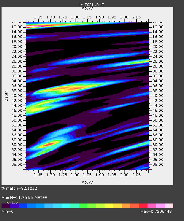
TX31 TXAR Array, Lajitas, TX, USA - Earthquake Result Viewer
| Earthquake location: |
Near East Coast Of Honshu, Japan |
| Earthquake latitude/longitude: |
37.7/142.0 |
| Earthquake time(UTC): |
2021/02/13 (044) 14:07:49 GMT |
| Earthquake Depth: |
54 km |
| Earthquake Magnitude: |
7.0 mww |
| Earthquake Catalog/Contributor: |
NEIC PDE/us |
|
| Network: |
IM International Miscellaneous Stations |
| Station: |
TX31 TXAR Array, Lajitas, TX, USA |
| Lat/Lon: |
29.33 N/103.67 W |
| Elevation: |
991 m |
|
| Distance: |
89.4 deg |
| Az: |
52.713 deg |
| Baz: |
313.707 deg |
| Ray Param: |
0.041820634 |
| Estimated Moho Depth: |
11.75 km |
| Estimated Crust Vp/Vs: |
1.60 |
| Assumed Crust Vp: |
6.419 km/s |
| Estimated Crust Vs: |
4.012 km/s |
| Estimated Crust Poisson's Ratio: |
0.18 |
|
| Radial Match: |
92.1012 % |
| Radial Bump: |
400 |
| Transverse Match: |
86.44544 % |
| Transverse Bump: |
400 |
| SOD ConfigId: |
23341671 |
| Insert Time: |
2021-02-27 15:20:51.112 +0000 |
| GWidth: |
2.5 |
| Max Bumps: |
400 |
| Tol: |
0.001 |
|

Signal To Noise
| Channel | StoN | STA | LTA |
| IM:TX31: :BHZ:20210213T14:20:09.125003Z | 3.1700833 | 8.955426E-7 | 2.8249812E-7 |
| IM:TX31: :BHN:20210213T14:20:09.125003Z | 1.002698 | 2.1448398E-7 | 2.1390686E-7 |
| IM:TX31: :BHE:20210213T14:20:09.125003Z | 1.573446 | 2.8139368E-7 | 1.788391E-7 |
| Arrivals |
| Ps | 1.1 SECOND |
| PpPs | 4.7 SECOND |
| PsPs/PpSs | 5.8 SECOND |


