You are here: Home > Network List > N4 - Central and EAstern US Network Stations List
> Station BGNE Belgrade, NE, USA > Earthquake Result Viewer
BGNE Belgrade, NE, USA - Earthquake Result Viewer
| Earthquake location: |
Near East Coast Of Honshu, Japan |
| Earthquake latitude/longitude: |
37.7/142.0 |
| Earthquake time(UTC): |
2021/02/13 (044) 14:07:49 GMT |
| Earthquake Depth: |
54 km |
| Earthquake Magnitude: |
7.0 mww |
| Earthquake Catalog/Contributor: |
NEIC PDE/us |
|
| Network: |
N4 Central and EAstern US Network |
| Station: |
BGNE Belgrade, NE, USA |
| Lat/Lon: |
41.41 N/98.15 W |
| Elevation: |
573 m |
|
| Distance: |
84.0 deg |
| Az: |
40.99 deg |
| Baz: |
316.227 deg |
| Ray Param: |
0.04567577 |
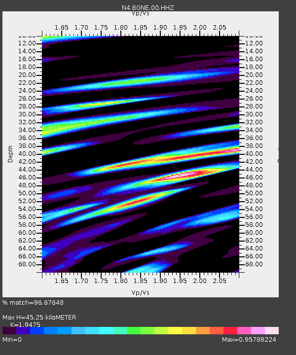
| Estimated Moho Depth: |
45.25 km |
| Estimated Crust Vp/Vs: |
1.95 |
| Assumed Crust Vp: |
6.53 km/s |
| Estimated Crust Vs: |
3.353 km/s |
| Estimated Crust Poisson's Ratio: |
0.32 |
|
| Radial Match: |
96.67648 % |
| Radial Bump: |
389 |
| Transverse Match: |
89.81808 % |
| Transverse Bump: |
400 |
| SOD ConfigId: |
23341671 |
| Insert Time: |
2021-02-27 15:22:47.539 +0000 |
| GWidth: |
2.5 |
| Max Bumps: |
400 |
| Tol: |
0.001 |
|

Signal To Noise
| Channel | StoN | STA | LTA |
| N4:BGNE:00:HHZ:20210213T14:19:43.239993Z | 8.420768 | 4.336422E-6 | 5.1496755E-7 |
| N4:BGNE:00:HH1:20210213T14:19:43.239993Z | 2.0063736 | 7.2236963E-7 | 3.6003746E-7 |
| N4:BGNE:00:HH2:20210213T14:19:43.239993Z | 0.93330425 | 4.39646E-7 | 4.7106394E-7 |
| Arrivals |
| Ps | 6.7 SECOND |
| PpPs | 20 SECOND |
| PsPs/PpSs | 27 SECOND |


