You are here: Home > Network List > N4 - Central and EAstern US Network Stations List
> Station K50A Casco, MI, USA > Earthquake Result Viewer
K50A Casco, MI, USA - Earthquake Result Viewer
| Earthquake location: |
Near East Coast Of Honshu, Japan |
| Earthquake latitude/longitude: |
37.7/142.0 |
| Earthquake time(UTC): |
2021/02/13 (044) 14:07:49 GMT |
| Earthquake Depth: |
54 km |
| Earthquake Magnitude: |
7.0 mww |
| Earthquake Catalog/Contributor: |
NEIC PDE/us |
|
| Network: |
N4 Central and EAstern US Network |
| Station: |
K50A Casco, MI, USA |
| Lat/Lon: |
42.77 N/82.62 W |
| Elevation: |
191 m |
|
| Distance: |
90.2 deg |
| Az: |
31.14 deg |
| Baz: |
326.137 deg |
| Ray Param: |
0.04170966 |
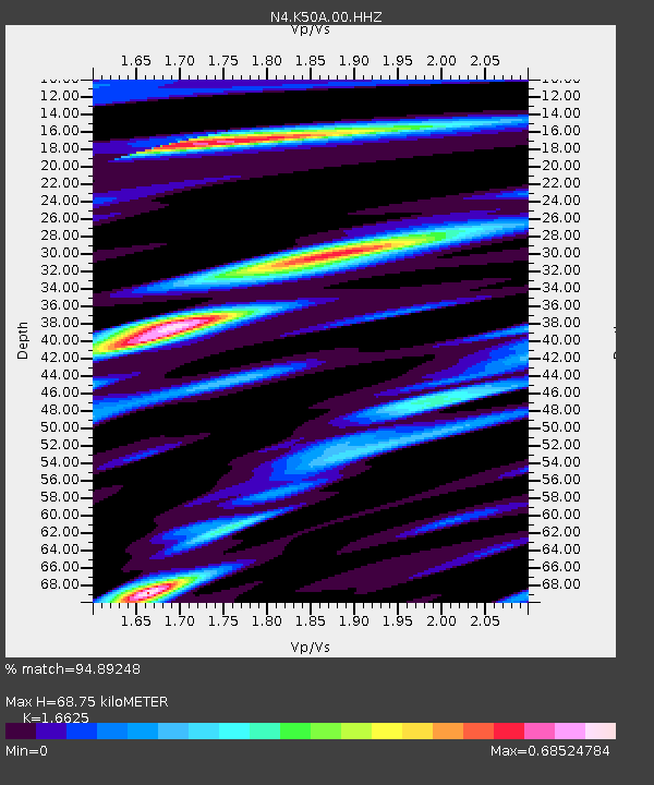
| Estimated Moho Depth: |
68.75 km |
| Estimated Crust Vp/Vs: |
1.66 |
| Assumed Crust Vp: |
6.483 km/s |
| Estimated Crust Vs: |
3.899 km/s |
| Estimated Crust Poisson's Ratio: |
0.22 |
|
| Radial Match: |
94.89248 % |
| Radial Bump: |
400 |
| Transverse Match: |
88.53059 % |
| Transverse Bump: |
400 |
| SOD ConfigId: |
23341671 |
| Insert Time: |
2021-02-27 15:23:14.087 +0000 |
| GWidth: |
2.5 |
| Max Bumps: |
400 |
| Tol: |
0.001 |
|

Signal To Noise
| Channel | StoN | STA | LTA |
| N4:K50A:00:HHZ:20210213T14:20:13.130008Z | 3.0709739 | 1.3627324E-6 | 4.4374602E-7 |
| N4:K50A:00:HH1:20210213T14:20:13.130008Z | 1.5240486 | 7.6615726E-7 | 5.027119E-7 |
| N4:K50A:00:HH2:20210213T14:20:13.130008Z | 1.0904964 | 3.1666593E-7 | 2.9038696E-7 |
| Arrivals |
| Ps | 7.2 SECOND |
| PpPs | 28 SECOND |
| PsPs/PpSs | 35 SECOND |


