You are here: Home > Network List > NM - Cooperative New Madrid Seismic Network Stations List
> Station PEBM Pemiscot Bayou,MO > Earthquake Result Viewer
PEBM Pemiscot Bayou,MO - Earthquake Result Viewer
| Earthquake location: |
Northern Chile |
| Earthquake latitude/longitude: |
-18.5/-69.6 |
| Earthquake time(UTC): |
2017/10/10 (283) 06:32:20 GMT |
| Earthquake Depth: |
82 km |
| Earthquake Magnitude: |
6.3 Mww |
| Earthquake Catalog/Contributor: |
NEIC PDE/us |
|
| Network: |
NM Cooperative New Madrid Seismic Network |
| Station: |
PEBM Pemiscot Bayou,MO |
| Lat/Lon: |
36.11 N/89.86 W |
| Elevation: |
76 m |
|
| Distance: |
57.6 deg |
| Az: |
340.644 deg |
| Baz: |
157.146 deg |
| Ray Param: |
0.06315368 |
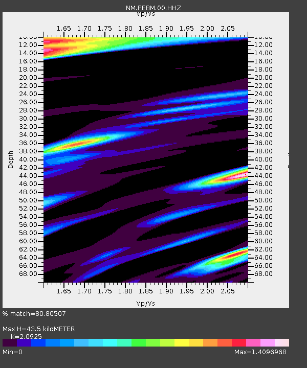
| Estimated Moho Depth: |
43.5 km |
| Estimated Crust Vp/Vs: |
2.09 |
| Assumed Crust Vp: |
6.444 km/s |
| Estimated Crust Vs: |
3.08 km/s |
| Estimated Crust Poisson's Ratio: |
0.35 |
|
| Radial Match: |
80.80507 % |
| Radial Bump: |
400 |
| Transverse Match: |
73.99349 % |
| Transverse Bump: |
400 |
| SOD ConfigId: |
2364251 |
| Insert Time: |
2017-10-24 06:36:50.545 +0000 |
| GWidth: |
2.5 |
| Max Bumps: |
400 |
| Tol: |
0.001 |
|

Signal To Noise
| Channel | StoN | STA | LTA |
| NM:PEBM:00:HHZ:20171010T06:41:31.555005Z | 21.489656 | 4.4777566E-6 | 2.08368E-7 |
| NM:PEBM:00:HHN:20171010T06:41:31.555005Z | 3.0559077 | 2.1502067E-6 | 7.036229E-7 |
| NM:PEBM:00:HHE:20171010T06:41:31.555005Z | 3.1601915 | 1.6198853E-6 | 5.125909E-7 |
| Arrivals |
| Ps | 7.7 SECOND |
| PpPs | 20 SECOND |
| PsPs/PpSs | 28 SECOND |


